
The Africatown community faces huge changes through proposed revisions to the City of Mobile Zoning Code. Advocates have released the following responses to the Planning Department. There is much to potentially be excited for, but unfortunately, there also appears to be many unnecessary and inappropriate zoning designations proposed, as well. As complex as this issue is, Africatown advocates agree that the City must wrestle with the contradictions in the current land use designations, how properties are being used, and the interests of the Africatown community to protect both its residential integrity and respect its many environmental concerns.
Build Mobile’s proposed Unified Development Code (UDC) Background
![]() Africatown residents and regional advocates, as well as many environmental justice community leaders from around Mobile provided significant participation during the Map for Mobile project. This resulted in the creation of a Future Land Use Map (FLUM) of the entire city that provided a non-binding sketch of what a comprehensive zoning map could look like.
Africatown residents and regional advocates, as well as many environmental justice community leaders from around Mobile provided significant participation during the Map for Mobile project. This resulted in the creation of a Future Land Use Map (FLUM) of the entire city that provided a non-binding sketch of what a comprehensive zoning map could look like.
The next step taken in the process to modernize the City of Mobile’s long-range planning processes was to examine all of the rules around getting “planning approval” for real estate developers, businesses, and residents in the city.
This culminated as the City of Mobile’s Build Mobile program. Its mission is ostensibly to consolidate and, in some places, “streamline” the planing approval process to make the land use rules that bind developers, business owners, and residents more transparent, modern, and less cumbersome. The Build Mobile process basically exists today as a sub-organization within the city’s Planning Department.
 In January 2019, Build Mobile submitted a draft of what they are calling the Unified Development Code (UDC) for public consideration, and it’s time to PROVIDE FEEDBACK. The original deadline for this general public comment period ended Friday, March 8, but the deadline has been extended another 30 days to April 8, 2019.
The entire 386 pages of the Build Mobile UDC code is available for review here.
On the Build Mobile website, they provide instructions for how to best navigate the document, and also, if you don’t really know what zoning is, what it does, what it doesn’t do, and more about why the city thought creating the UDC was necessary, they provide an FAQ to learn more about.
Once this round of public comment is received, Build Mobile will then adjust the UDC and submit it to the City of Mobile Planning Commission for a formal public hearing process. If passed there, it will then go to the Mobile City Council for a final public hearing and vote.
If passed there, the whole UDC will replace the existing municipal code Chapter 64 that covers zoning in the city. The accompanying UDC zoning map will also be approved and new designations will be formally adopted, replacing the old, and fairly inconsistently applied, zoning designations entirely.
A link to the Build Mobile online portal is provided with each of our comments so you can then send your own commentary about the same segments to Build Mobile and help drive justice-oriented participation in this process.
Please encourage your friends to read more about it and contribute, as well.
If you know folks who cannot use a computer well or who simply don’t want to do the work, ask how they feel about something, get their permission, and submit a comment on their behalf!
If we missed something or got something wrong, SEND YOUR COMMENT TO BUILD MOBILE and then please bring it to our attention, too, cause we want to hear your thoughts, as well.
MEJAC’s General Comments on the proposed UDC
MEJAC has found a lot of specific planning approval changes in the UDC that are thoughtful and worthy of praise. There are also some changes in the UDC that are disappointingly unhelpful.
In the proposed UDC Appendix A Overlay-Neighborhood Conservation, Section 64-201 Africatown Overlay (O-AF), the Africatown Neighborhood Plan would be implemented. This is a momentous occasion reflecting years of commitment by hundreds of Africatown residents, residential stakeholders, and regional advocates.
However, because the Africatown Neighborhood Plan was developed prior to the introduction of new zoning designations by the Build Mobile team, in order to provide the Build Mobile team with the best information regarding how these new zoning definitions affect the possibilities held within the Africatown Neighborhood Plan, MEJAC has submitted dozens of constructive comments for parcels within the Africatown Overlay district and its proposed UDC zoning map.
While our comments may appear to be very Africatown-centered, MEJAC is always looking for ways that the good things happening in Africatown in the proposed UDC could be enhanced and applied in other parts of the City of Mobile, as well! Many of our comments are not specifically relevant to Africatown.
As an organization, MEJAC is looking at the proposed UDC with several principles in mind that shape our concerns and our excitement:
-
Communities should be aware of and involved in the development of their neighborhoods. The Neighborhood Meeting standards as defined in the proposed UDC Article VI Procedures, Section 64-104 Neighborhood Meetings (p. 198) provide landmark guidelines that would strongly address the alienation some residents feel from their own community development and re-development processes. These standards must respond to industrial and maritime district developments, particularly where such developments affect residential neighborhood quality of life.
-
Vacant lots and parcels of land where just grass or woods currently are, do not need to be given the most permissive forms of land use zoning the city affords even if their adjacent, developed lots are zoned permissively. This is to protect community participation in the development of open spaces within and around neighborhoods for environmental, aesthetic, and other quality of life interests. If there are plans for these otherwise vacant sites, the city should be encouraging developers to be transparent about their plans. If there are no plans, there is little justification for providing permissive zoning designations.
-
Lots and parcels of land that are currently zoned as Residential must not be given commercial or industrial zoning designations without public participation, particularly in the Africatown Overlay whose Africatown Neighborhood Plan documents very clearly that residential participation in more permissive land use changes is paramount. The proposed UDC Article VI Procedures, Section 64-104 Neighborhood Meetings (p. 198) standards should be mandatory throughout the entire Africatown Overlay and the proposed UDC Neighborhood Meeting standards should be employed ahead of sweeping changes in zoning designations instead of fast-tracking a massive rezoning project without the kind of accountability and transparency afforded by public meetings and hearings.
-
Industrial blight is too often overlooked as a contributor to residential and commercial blight. Landscaping, appropriate street trees, side walks, bike paths, greenways, and other community amenities make neighborhoods attractive to investment from families and community-oriented businesses. As such, areas in desperate need of reinvestment of this nature like the Africatown Planning Area should have equitable requirements for landscaping and pedestrian walking path standards for both development and re-development purposes. These requirements should be extended with particular attention given with respect to commercial and industrial developments of any kind along public rights-of-way.
-
The right zoning for a parcel’s current land use should be a driving consideration for the UDC map’s proposed zoning changes as well as its proposed zoning continuities. There is no reasonable logic for providing overly permissive zoning designations for land uses that fall within less permissive designations that would not in any way hamper a current land use.
-
MEJAC is very concerned for other neighborhoods within the City of Mobile that may not have as robust of a review process as the Africatown community for the sweeping zoning changes proposed within the UDC zoning map that will directly effect their neighborhoods.
MEJAC sees incredible potential for the ideas contained within the proposed UDC to positively impact the quality of life in some of Mobile’s most vulnerable neighborhoods, but many of the proposed UDC’s deficiencies must be addressed, particularly with respect to the Africatown community’s thoroughly documented wishes for its neighborhood development and redevelopment processes.
MEJAC’s Specific Comments on the proposed UDC
Table of Contents:
Reference Map 1) Existing Africatown Zoning Map
Reference Map 2) Africatown Neighborhood Plan Existing Land Use Map
Reference Map 3) Africatown Neighborhood Plan Future Land Use Map (FLUM)
Reference Map 4) Map for Mobile Future Land Use Map (FLUM)
Reference Map 5) Proposed UDC Africatown Zoning MAP
Parcel Comment 1) Africatown Connections Blueway Place of Baptisms
Parcel Comment 2) Josephine Allen & Three Mile Creek in Africatown
Parcel Comment 3) Lewis Quarters in Africatown
Parcel Comment 4) Africatown Connections Blueway Lewis Landing 2
Parcel Comment 5) Africatown Connections Blueway Lewis Landing 1
Parcel Comment 6) Africatown Connections Blueway Clotilda Landing Place
Parcel Comment 7) Hog Bayou Natural Gas Power Plant Zoning
Parcel Comment 8) De-zoning Vacant Properties
Parcel Comment 9) The “old Scott Credit Union” Parcels in Africatown
Parcel Comment 10) The “New Quarters” Subdivision in Africatown
Parcel Comment 11) Eastern Magazine Point & Williams Motel in Africatown
Parcel Comment 12) Kimberly-Clark R2-to-Commercial Warehouse Rezoning
Parcel Comment 13) Paper Mill Road R1-to-Industrial Heavy Zoning 1
Parcel Comment 14) Meaher Vacant Land R1-to-Industrial Heavy Zoning
Parcel Comment 15) Telegraph Road Up-Zonings
Parcel Comment 16) Telegraph Road Residential-to-Industrial Rezoning
Parcel Comment 17) DPC Residential-to-Industrial Rezoning
Parcel Comment 18) Paper Mill Road Vacant Lot R1-to-Industrial Heavy Rezoning
Parcel Comment 19) A-1 Stop Convenience Store R1-to-Industrial Light Rezoning
Parcel Comment 20) Metals USA New Zoning Designation
Parcel Comment 21) Showers of Blessings Church R1-to-Industrial Rezoning
Parcel Comment 22) Telegraph Road Vacant Lot R1-Industrial Rezoning
Parcel Comment 23) Merchants Transfer Co R1-to-Industrial Rezoning
Parcel Comment 24) Miller Transporters Chemical Tank Cleaning Parcel Zoning
Parcel Comment 25) Telecommunications Tower Parcel Zoning
Parcel Comment 26) Transouth Holdings LLC Partially Vacant Parcel Zoning
Parcel Comment 27) Cemex Bulk Cement Distribution Zoning
Parcel Comment 28) International Paper Utility and Railroad Easement Parcels
Parcel Comment 29) Gulf City Shell Corporation R1-to-Industrial Rezoning
Parcel Comment 30) Alabama Power Minor Utility and Utility Easement Tract
Parcel Comment 31) Former Multisorb Technologies Warehouse and Refinery Site
Parcel Comment 32) Terminal Railroad Spur Easement Parcels
Parcel Comment 33) Olivet Church R1-to-Industrial Light Rezoning
Parcel Comment 34) Henry J Reid Fire Station Zoning
Parcel Comment 35) Heavy Equipment Rental and Storage Facility Zoning
Parcel Comment 36) Gulf Coast Marine Supply Industrial Zoning
Parcel Comment 37) Vacant Parcel Telegraph Road Zoning
Parcel Comment 38) B & B Industrial Supply Zoning
Parcel Comment 39) Young Transport Zoning
Parcel Comment 40) Vacant Lot Telegraph Road Zoning
Parcel Comment 41) Telegraph Road Vacant Tract B2-to-Industrial Rezoning
Parcel Comment 42) Telegraph Road Vacant Parcel Zoning
Parcel Comment 43) Lift Parts Service Company Inc Zoning
Parcel Comment 44) Vacant Alabama MHMR Lot Zoning
Parcel Comment 45) Vacant MAWSS Lot on Telegraph Road Zoning
Code Comment 1) Conservation Subdivision Standards
Code Comment 2) Public Tree Removal Authority
Code Comment 3) Tree Removal Permitting Process
Code Comment 4) Industrial/Residential District Buffer Standards
Code Comment 5) Riparian Buffers Standard Applicability
Code Comment 6) Exemptions from Riparian Buffer Standards
Code Comment 7) New Coal Handling Operations Standards Applicability
Code Comment 8) New Coal Handling Operations Standards Regulations
Code Comment 9) Above-Ground Storage Tank Standards Applicability
Code Comment 10) Above-Ground Storage Tank Standards Applicability
Code Comment 11) Above-Ground Storage Tank Standards Applicability
Code Comment 12) Neighborhood Meeting Requirements
Code Comment 13) Africatown Zoning Overlay CPTED Standards
Code Comment 14) Africatown Zoning Overlay Landscaping Standards
 Reference Map 1) Existing Africatown Zoning Map:
This map of the existing zoning districts in the Africatown Planning Area was assembled as a composite from the City of Mobile’s Planning & Zoning public ArcGIS mapping software in March 2019.
Click on the image to the right to see map details.
 Reference Map 2) Africatown Neighborhood Plan Existing Land Use Map:
This map approximating the existing land use in the Africatown Planning Area appears in the Planning Commission-approved Africatown Neighborhood Plan the final draft of which was approved on in April, 21 2016.
Click on the image to the right to see map details.
 Reference Map 3) Africatown Neighborhood Plan Future Land Use Map (FLUM):
This map offering a vision for future land use in the Africatown Planning Area appears in the Planning Commission-approved Africatown Neighborhood Plan the final draft of which was approved on in April, 21 2016.
Click on the image to the right to see map details.
 Reference Map 4) Map for Mobile Future Land Use Map (FLUM), focused on the Africatown Planning Area:
This map of the Map for Mobile-guided Future Land Use Map non-binding zoning designations in the Africatown Planning Area was assembled as a composite from the City of Mobile’s Planning & Zoning public ArcGIS mapping software in March 2019.
Click on the image to the right to see map details.
 Reference Map 5) Proposed UDC Africatown Zoning MAP, focused on the Africatown Planning Area:
This composite map of the proposed UDC zoning for the Africatown Planning Area was assembled from the City of Mobile’s UDC interactive web map in March 2019.
Click on the image to the right to see map details.
If this map is adopted, all zoning designations in it are binding. This is the proposed map of future zoning district assignments that MEJAC’s Parcel Comments respond to.
Parcel Comment 1) Africatown Connections Blueway Place of Baptisms

Illustration 1.1 – Reference parcel highlighted green in the proposed UDC composite map
Illustration 1.1 to the right, PropertyID: R022902440019003.01 (Parker Towing Co Inc)
Previously, both the Planning Commission approved Africatown Neighborhood Plan FLUM and the Map for Mobile FLUM had identified this tract and portions of adjoining tracts as “Parks & Open Space”. Now in the proposed Build Mobile UDC, it is designated as Heavy Industrial.

Illustration 1.2 – Reference tracts in the Africatown Neighborhood Plan FLUM
The National Park Service- facilitated Africatown Connections Blueway Planning Team had used the Africatown Neighborhood Plan and Map for Mobile FLUMs to identify this site as a Point of Interest in its planning process, and the “Parks & Open Space” tract was envisioned as a boardwalk trail through the site’s undeveloped wetlands to Three Mile Creek to honor the Africatown community’s heritage of Three Mile Creek being a primary location for baptisms and other water-dependent ceremonial uses in the area. The Africatown Neighborhood Plan FLUM can be seen to the left as Illustration 1.2, and the Map for Mobile FLUM can be seen to the right as Illustration 1.3.

Illustration 1.3 – Reference tracts highlighted green in the Map for Mobile FLUM composite map
It is disheartening to see a site of opportunity and possibility be excluded from the UDC. Given the current land use on the western parts of most of the Map for Mobile FLUM-identified tract by Parker Towing Co Inc, it would be reasonable to pair down the parcels involved with this potential Park & Open Space parcel tract to those which are currently vacant, undeveloped, and largely composed of wetlands acting as a drainage ditch for stormwater runoff. Those would include the former Terminal Railroad easement land, R022902440019003.01 (Parker Towing Co Inc), the State of Alabama land on which Terminal Railroad’s current easement currently runs, R022902440002006.01 & R022902440019003.01 (State of Alabama), and R022902440002101., a small vacant parcel owned by Chippewa Lakes LLC. The tract that these combined parcels form is Illustration 1.4 below and to the left.

Illustration 1.4 – Reference tract highlighted green in the proposed UDC composite map
All or any combination of these parcels could still serve as an effective conduit for pilgrimage to where Africatown community members remember their families being baptized in Three Mile Creek. It would not be surprising to learn that there may be assistance to refurbish and re-utilize this land as part of a “rails to trails” program.

Illustration 1.5 – A sketch of the Place of Baptisms by MSU
Students at Mississippi State University in partnership with the National Park Service-facilitated Africatown Connections Blueway Planning Team developed some preliminary sketches of this and several other possible points of interest. Illustrations 1.5 and 1.6 offer an idea about how the residents who partnered with the MSU students view the possibilities of the site.

Illustration 1.6 – A sketch of the Place of Baptisms by MSU
A path forward with respect to the potential that this corner of Africatown holds for creative placemaking would be very welcome. The Africatown Connections Blueway Planning Team is committed to exploring creative ways to capture the unique and under-resourced heritage of the Africatown community as recreational and educational projects for community benefit and as heritage tourism points of interest.
Parcel Comment 2) Josephine Allen & Three Mile Creek in Africatown

Illustration 2.1 – Reference parcel highlighted green in the proposed UDC composite map
Illustration 2.1 to the right, PropertyID: R022902440018013. (Marvin Mostellar Jr)
This parcel and the parcels immediately to its west stretching along Three Mile Creek from Telegraph Road to I-165 including R022902440018013., R022902440018014. (Marvin Mostellar Jr), R022902440018015. (MFBS/Gulf Lumber Co), R022902440017042. (MFBS/Gulf Lumber Co), and R022902440017043. (MFBS/Gulf Lumber Co). are proposed in the UDC to be re-classified from I-2 to Maritime Light. This tract of parcels is shown below to the left highlighted together in Illustration 2.2.

Illustration 2.2 – Reference tract highlighted green in the proposed UDC composite map
All of these sites are undeveloped and currently vacant.
The Maritime Light designation for this site and others similarly to the west of Telegraph Road are not appropriate, because the bridge at Telegraph Road is not navigable by any type of commercial barge that could potentially service a “Maritime Light” district.
“Maritime Light” is described in Article II Zoning Districts, Section 64-24 Maritime (MM, ML, and MH) Purpose (p. 15) as including “maritime supporting, commercial uses within the Downtown Waterfront (DW) future land use category, and maritime light industrial and support activities that occur adjacent to water dependent uses, all of which are removed or buffered from residential uses”.
Given the need to support the residential nature of the land adjacent to the former Josephine Allen Housing Projects and for the benefit of residents who live across the street from these properties on Stimrad Road, it doesn’t appear that the proposed Maritime Light designation for these parcels is “removed or buffered from residential uses” at all.
A Maritime Mixed Use designation would certainly be more appropriate, but given the vast swath of undeveloped waterfront along Three Mile Creek and that all Maritime districts are proposed in the UDC to be exempt from the Riparian Buffer standards in Article IV Development Standards, Section 64-59 Natural Resource Protection, C, 6, (d) (p.120), a use designation that affirms the residential nature of these properties’ immediate geographic neighbors and promotes the beautiful waterfront these parcels enjoy, such as a Residential Low Density (C) conforming to Site Design Type 2A (Conservation Subdivision), as described in Article III Composite Standards, Section 64-43 Site Design, D (p. 52), appears to be an ideal alternative designation for each of these properties.
A RL(C) designation would also help nicely tie the potential beautification of lower Three Mile Creek together with the strides being taken further upstream and reinforce the National Park Service-facilitated Africatown Connections Blueway planning team’s vision of heritage-oriented recreational water access along lower Three Mile Creek to honor its significance to Historic Africatown.
The parcels relevant to this comment include R022902440018013., R022902440018014., R022902440018015., R022902440017042., and R022902440017043.
Parcel Comment 3) Lewis Quarters in Africatown

Illustration 3.1 – Reference parcel highlighted green in the proposed UDC composite map
Illustration 3.1 to the right, PropertyID: R022902440017134.
This parcel and the parcels immediately around it that comprise the historic Lewis Quarters are proposed to be rezoned from I-2 to Residential Low Density (B), which is a very necessary improvement in the zoning designation for this community of historic Africatown.

Illustration 3.2 – Lewis Quarters tract highlighted green in the proposed UDC composite map
However, it is still very concerning that the only road to and from the community, Lewis Quarters, is still not designated as a public right-of-way but as a private drive on the property of Canfor (previously Scotch & Gulf Lumber). It’s hard to imagine that the lack of public right-of-way to their residential neighborhood is a standard land use pattern in conformity with neighborhood design standards anywhere else in the city. Although this may or may not fall out of the scope of zoning concerns within the proposed UDC, the public right-of-way situation ought to be remedied for the sake of property values of and public safety concerns for the residents of Lewis Quarters.
The parcels relevant to this comment include R022902440017134., R022902440017135., R022902440017140., R022902440017136., R022902440017137., R022902440017139., R022902440017138., R022902440017133., R022902440017132., R022902440017131., R022902440017130., R022902440017127., and R022902440017128. and are shown above to the left as Illustration 3.2.
Parcel Comment 4) Africatown Connections Blueway Lewis Landing 2

Illustration 4.1 – Reference parcel highlighted green in the proposed UDC composite map
Illustration 4.1 to the right, PropertyID: R022902440021001. (Scotch & Gulf Lumber LLC/Canfor)
This parcel located on Three Mile Creek northeast of Conception Street Road was identified by the National Park Service-facilitated Africatown Connections Blueway Planning Team as a potential Point of Interest for its blueway project due to its current informal use as a fishing and boat launch point along Three Mile Creek.
The site is almost entirely undeveloped and currently vacant except for a natural drainage ditch for stormwater runoff from the Canfor lumber treatment facility (formerly Gulf & Scotch Lumber) and some loose aggregated poured onto the site for the benefit of the site’s soil retention and recreational patrons.
The Maritime Light designation for this site and others similarly to the west of Telegraph Road are not appropriate, because the bridge at Telegraph Road is not navigable by any type of commercial barge that could potentially service a “Maritime Light” district.
“Maritime Light” is described in Article II Zoning Districts, Section 64-24 Maritime (MM, ML, and MH) Purpose (p. 15) as including “maritime supporting, commercial uses within the Downtown Waterfront (DW) future land use category, and maritime light industrial and support activities that occur adjacent to water dependent uses, all of which are removed or buffered from residential uses”.
The concern with this parcel’s proposed designation is simply the desire to affirm that its potential new zoning doesn’t preclude development of this site as a formal fishing and boat launch point for Three Mile Creek access, recognition of its proximity to Lewis Quarters, and its historic connection to the Africatown Planning Area.
Parcel Comment 5) Africatown Connections Blueway Lewis Landing 1

Illustration 5.1 – Reference parcel highlighted green in the proposed UDC composite map
Illustration 5.1 to the right, PropertyID: R022904102000002.
This parcel location on Three Mile Creek southwest of Conception Street Road was identified by the National Park Service-facilitated Africatown Connections Blueway Planning Team as a potential Point of Interest for its blueway project due to its current informal use as a fishing point along Three Mile Creek.
This site is completely undeveloped and currently vacant and it boasts stunning panoramic views of the confluence of three tributaries of Three Mile Creek.
The Maritime Light designation for this site and others similarly to the west of Telegraph Road are not appropriate, because the bridge at Telegraph Road is not navigable by any type of commercial barge that could potentially service a “Maritime Light” district.
“Maritime Light” is described in Article II Zoning Districts, Section 64-24 Maritime (MM, ML, and MH) Purpose (p. 15) as including “maritime supporting, commercial uses within the Downtown Waterfront (DW) future land use category, and maritime light industrial and support activities that occur adjacent to water dependent uses, all of which are removed or buffered from residential uses”.
The concern with this parcel’s proposed designation is simply the desire to affirm that its potential new zoning doesn’t preclude development of this site as a formal fishing and boat launch point for Three Mile Creek access, recognition of its proximity to Lewis Quarters, and its historic connection to the Africatown Planning Area.
Parcel Comment 6) Africatown Connections Blueway Clotilda Landing Place

Illustration 6.1 – Reference parcel highlighted green in the proposed UDC composite map
Illustration 6.1 to the right, PropertyID: R022208440021002. (Great Magnolia Properties LLC)
This parcel and the parcel to its immediate south, R022902440001001. (Great Magnolia Properties LLC), were identified by the National Park Service-facilitated Africatown Connections Blueway Planning Team as a potential Point of Interest for its blueway project due to their proximity to the Mobile River waterfront, Magazine Point, and the Cochrane-Africatown USA Bridge, which has a large footprint owned by Alabama Department of Transportation with Mobile River waterfront, as well.

Illustration 6.2 – Reference parcel highlighted green in the proposed UDC composite map
These sites are all undeveloped and vacant except for the Cochrane-Africatown USA Bridge overhead and some fencing and derelict security flood lights along what appears to be a former storage yard of some sort on the Great Magnolia Properties LLC land. These tracts are shown together as Illustration 6.2 to the left.
Oral traditional and the available documentation suggests that the Africatown-founding shipmates disembarked the infamous Clotilda schooner while it was anchored nearby and were brought ashore in small groups at what is currently known as Magazine Point to walk on land for the first time since being stolen from Africa. However, given that there is no vacant waterfront property on Magazine Point any longer due to the petrochemical above ground storage tank farm expansion of the 1960s and 70s, the land under the Cochrane-Africatown USA Bridge and the two properties referenced here, which are to its immediate north, could be utilized as Park & Open Space in recognition of the end of the Trans-Atlantic Slave Trade.
The land under the Cochrane-Africatown USA Bridge is already being used by nearby residents as an informal fishing and recreational space, and a public right-of-way to the parcels already exists. Also, this is another site where Mississippi State University landscape architecture students worked with Africatown residents to draw up potential site plans to honor its significance to the critically important history of Africatown.
Vacant parcels do no warrant Industrial Heavy zoning designations especially when other land uses are plausible. MEJAC would simply like to see that any potential zoning wouldn’t preclude development of this site as a formal fishing and recreational space affording many possible amenities for a city with no other public access boat launch points on the Mobile River at all.
The parcels relevant to this comment include R022208440021002. and R022208440021001.
Parcel Comment 7) Hog Bayou Natural Gas Power Plant Zoning

Illustration 7.1 – Reference parcel highlighted green in the proposed UDC composite map
Illustration 7.1 to the right, PropertyID: R022208440012002.003. (Alabama State Port Authority)
This parcel on Hog Bayou and the two parcels to its immediate east, R022208440012002.007. (Alabama State Port Authority) and R022208440011001. (International Paper Co), are all proposed in the UDC to have their zoning districts changed from I-2 to Maritime Light, but the parcels have a natural gas power plant that sprawls across the property boundaries of each of them, which is a land use that would be classified in the UDC as either a Major or Minor Utility.

Illustration 7.1 – Reference tracts highlighted green in the proposed UDC composite map
The Article II Zoning Districts, Section 64-31 Use Table (p. 29) doesn’t provide for Minor Utility land use in Maritime Light districts, and Major Utility land use is neither permitted nor conditional in any Maritime district at all. If the two parcels owned by the Alabama State Port Authority are exempt from conformity with the City of Mobile’s zoning code, shouldn’t the parcel owned by International Paper Co, which appears to have part of the natural gas power plant on its property, be subject still? The tracts highlighted together are shown to the left as Illustration 7.2.
The fact that a Minor Utility could be granted a conditional use for Maritime Mixed Use or Maritime Heavy districts and not Maritime Light districts could be an accident or an oversight, and the City of Mobile GIS web applications that suggest portions of the power plant are sited on International Paper Co property could be inaccurate. In fact, given the construction of two natural gas turbines on Kimberly Clark’s property, this power plant may be slated for decommission, rendering this concern moot. Ultimately, the contradiction of this tract’s proposed UDC zoning designation and its current land use should be addressed and clarified regardless of potential zoning and land use regulatory exemption.
The parcels relevant to this comment include R022208440012002.007., R022208440012002.003., and R022208440011001.
Parcel Comment 8) De-zoning Vacant Properties

Illustration 8.1 – Reference parcel highlighted green in the proposed UDC composite map
Illustration 8.1 to the right, PropertyID: R022901000008004. (Arc Terminals Mobile Holdings LLC)
This parcel and the two adjoining parcels to its south, R022901000008005.001. and R022905000002001.002., are on Blakeley Island east of Cochrane Causeway Road, and they appear to be completely vacant and have been for many years. There seems to be very little logic in keeping vacant properties with no activity on them whatsoever designated as Industrial Heavy. The tract of parcels, all held by Arc Terminals Mobile Holdings LLC, is shown below and to the left as Illustration 8.2.

Illustration 8.2 – Reference tract highlighted green in the proposed UDC composite map
Parcels that are vacant and undeveloped do not warrant the most permissive zoning designations afforded by the City of Mobile regardless of current zoning.

Illustration 8.3 – Reference tract highlighted green in the proposed UDC composite map
These properties are on Blakeley Island, but the principle should be consistently followed with similar properties in places like Africatown, as well, which would include R022208440012002. and R022208440012002.004., both Hydrocarbon of Mobile LLC property and shown to the right as Illustration 8.3.
The parcels relevant to this comment include R022901000008004., R022901000008005.001., R022905000002001.002., R022208440012002., and R022208440012002.004.
Parcel Comment 9) The “old Scott Credit Union” Parcels in Africatown

Illustration 9.1 – Reference parcel highlighted green in the proposed UDC composite map
Illustration 9.1 to the right, PropertyID: R022902440002017.001. (Chippewa Lakes LLC)
This parcel and its related parcels, R022902440002017., R022208440020049., and R022208440020049.02, form an area in the Africatown community that many refer to as “the old Scott Credit Union” land and are shown together highlighted in Illustration 9.2 to the left. They are all owned by Chippewa Lakes LLC. Many controversial land uses have been proposed for these properties in the relatively recent past, and at the Build Mobile Africatown focus group meeting on Tuesday, February 26 at the Robert Hope Community Center some residents expressed concerns that plans of which they were never made aware are being implemented via the potential passage of the UDC.
Due to the erosion that has been perpetrated upon the residential integrity of the Africatown community, any loss of land zoned as Residential makes many uncomfortable, regardless of motive.

Illustration 9.2 – Reference tract highlighted green in the proposed UDC composite map
When the Scott Credit Union business was proposed, the concerns about residential integrity were raised, and the planning approval process permitted the re-zoning of the land to allow the credit union to operate as conditional. This conferred only the use of the land as a credit union, and upon the credit union’s closure, the land reverted back to its previous Residential-2 zoning. This is why the land has a shuttered banking facility on it but is nevertheless zoned Residential-2.

Illustration 9.3 – Reference tract highlighted magenta in the Existing Africatown Zoning composite map
The two parcels where the old Scott Credit Union operated along Paper Mill Road are currently zoned Residential-1. The two parcels that touch the road identified in the UDC as “Paper Mill Road Extension”, which in Africatown is known as “Tin Top Alley”, are currently zoned Residential-2 with a segment of the southernmost parcel along Africatown Boulevard currently zoned as Business-2. All of these parcels are proposed under the UDC to be re-zoned as Traditional Neighborhood Center (NCT), as shown above and to the left as Illustration 9.2. The current zoning of these tracts is shown to the right as Illustration 9.3.
The permitted land use standards for Traditional Neighborhood Center found in Article II Zoning Districts, Section 64-31 Use Table (p. 25-27) are less concerning to most residents than the process of getting to that designation. However, due to the longstanding, thoroughly documented, and legitimate concerns over losing Residential and Business zoned land to any other designation, some residents, residential stakeholders, and regional advocates would rather see a process that helps actually shed light to residents about any potential plans for the parcels.
Many residents feel deliberately left out of consultative processes rumored to be happening with small groups of residents. While this concern appears to be remedied for future re-zoning planning approval processes in accordance with Article VI Procedures, Section 64-104 Neighborhood Meetings (p. 198), to apply so many changes to a neighborhood in the adoption of a document with many good aspirational goals when so many feel left out of the process of positive change-making in their neighborhood would be a truly wrong foot to start on for the UDC.
As the proposed UDC recognizes, communities deserve to be involved in the development of their neighborhoods. Because political transparency and equitable community participation has been a struggle for some residents in Africatown who have otherwise proven consistently committed to participating in neighborhood planning efforts and also due to the recent heightened community interest around this site, a proper public rezoning hearing after the UDC adoption process may be the best path forward unless those seeking this rezoning hold a neighborhood meeting similar to what is prescribed in Article VI Procedures, Section 64-104 Neighborhood Meetings (p. 198) before the UDC is submitted to the Planning Commission for consideration.
A neighborhood meeting of this nature would help usher the Africatown community closer to the more equitable and inclusive future envisioned by the Africatown Neighborhood Plan.
Parcel Comment 10) The “New Quarters” Subdivision in Africatown

Illustration 10.1 – Reference parcel highlighted green in the proposed UDC composite map
Illustration 10.1 to the right, PropertyID: R022208440019002. (Bean Properties LLC)
This parcel and the triangular parcel to its immediate north, R022208440012007. (Bean Properties LLC), form an area in the Africatown community that many remember as the old “New Quarters” housing subdivision, as shown in Illustration 10.2 below and to the left. Many controversial land uses have been executed upon this parcel of land over the years in nonconformity with the existing zoning code, and controversial land uses have been proposed for these properties in the relatively recent past.

Illustration 10.2 – Reference tract highlighted green in the proposed UDC composite map
The New Quarters land was purchased by the Alabama State Port Authority from International Paper and was more recently sold to Bean Properties LLC, which sought to re-zone the district from Residential-1 to Industrial-2. Motivated by many of the same concerns which re-manifested during the “Scott Credit Union” re-zoning application process shortly after the New Quarters land planning approval process, residents, residential stakeholders, and regional advocates came together to oppose the application, and after a well attended community meeting in Africatown, the Planning Commission voted against the re-zoning.

Illustration 10.3 – Reference tract highlighted magenta in the Existing Africatown Zoning composite map
These parcels of land are currently zoned Residential-1, and the proposed UDC would re-zone them as Traditional Neighborhood Center (NCT). A map of the current zoning is shown as Illustration 10.3 to the right.
The permitted land use standards for Traditional Neighborhood Center found in Article II Zoning Districts, Section 64-31 Use Table (p. 25-27) are less concerning to most residents than the process of getting to that designation. However, due to the longstanding, thoroughly documented, and legitimate concerns over losing Residential and Business zoned land to any other designation, some residents, residential stakeholders, and regional advocates would rather see a process that helps actually shed light to residents about any potential plans for the parcels.
Many residents feel deliberately left out of consultative processes rumored to be happening with small groups of residents. While this concern appears to be remedied for future re-zoning planning approval processes in accordance with Article VI Procedures, Section 64-104 Neighborhood Meetings (p. 198), to apply so many changes to a neighborhood in the adoption of a document with many good aspirational goals when so many feel left out of the process of positive change-making in their neighborhood would be a truly wrong foot to start on for the UDC.
As the proposed UDC recognizes, communities deserve to be involved in the development of their neighborhoods. Because political transparency and equitable community participation has been a struggle for some residents in Africatown who have otherwise proven consistently committed to participating in neighborhood planning efforts and also due to the recent heightened community interest around this site, a proper public rezoning hearing after the UDC adoption process may be the best path forward unless those seeking this rezoning hold a neighborhood meeting similar to what is prescribed in Article VI Procedures, Section 64-104 Neighborhood Meetings (p. 198) before the UDC is submitted to the Planning Commission for consideration.
A neighborhood meeting of this nature would help usher the Africatown community closer to the more equitable and inclusive future envisioned by the Africatown Neighborhood Plan.
Parcel Comment 11) Eastern Magazine Point & Williams Motel in Africatown

Illustration 11.1 – Reference parcel highlighted green in the proposed UDC composite map
Illustration 11.1 to the right, PropertyID: R022902440002023. (Chippewa Lakes LLC)

Illustration 11.2 – Reference tract highlighted green in the proposed UDC composite map
This parcel together with R022902440002021. (Chippewa Lakes LLC), R022902440002022.001. (Kanta and Roman Patel), and R022902440002020. (Chippewa Lakes LLC) have been vacant for many years except for the Williams Motel on R022902440002022.001. These parcels together are shown in Illustration 11.2 to the left. The vacant land was not landscaped to prevent erosion and has seen much topsoil erode into Three Mile Creek to its south.

Illustration 11.3 – Reference tract highlighted magenta in the Existing Africatown Zoning composite map
This parcel is proposed to be re-zoned in the UDC from Residential-1 to Traditional Neighborhood Center (NCT). The parcels across Chin St. to its east, including where the Williams Motel has been operating, currently enjoys a split zoning between Business-1 where the motel sits and Residential-1 to the south of the motel along Chin St and are all proposed in the UDC to be re-zoned as NCT, as well. The existing zoning for the parcels is shown in Illustration 11.3 to the right.
The permitted land use standards for Traditional Neighborhood Center found in Article II Zoning Districts, Section 64-31 Use Table (p. 25-27) are less concerning to most residents than the process of getting to that designation. However, due to the longstanding, thoroughly documented, and legitimate concerns over losing Residential and Business zoned land to any other designation, some residents, residential stakeholders, and regional advocates would rather see a process that helps actually shed light to residents about any potential plans for the parcels.
Many residents feel deliberately left out of consultative processes rumored to be happening with small groups of residents. While this concern appears to be remedied for future re-zoning planning approval processes in accordance with Article VI Procedures, Section 64-104 Neighborhood Meetings (p. 198), to apply so many changes to a neighborhood in the adoption of a document with many good aspirational goals when so many feel left out of the process of positive change-making in their neighborhood would be a truly wrong foot to start on for the UDC.
As the proposed UDC recognizes, communities deserve to be involved in the development of their neighborhoods. Because political transparency and equitable community participation has been a struggle for some residents in Africatown who have otherwise proven consistently committed to participating in neighborhood planning efforts and also due to the recent heightened community interest around this site, a proper public rezoning hearing after the UDC adoption process may be the best path forward unless those seeking this rezoning hold a neighborhood meeting similar to what is prescribed in Article VI Procedures, Section 64-104 Neighborhood Meetings (p. 198) before the UDC is submitted to the Planning Commission for consideration.
A neighborhood meeting of this nature would help usher the Africatown community closer to the more equitable and inclusive future envisioned by the Africatown Neighborhood Plan.
Parcel Comment 12) Kimberly-Clark Residential-to-Commercial Warehouse Rezoning
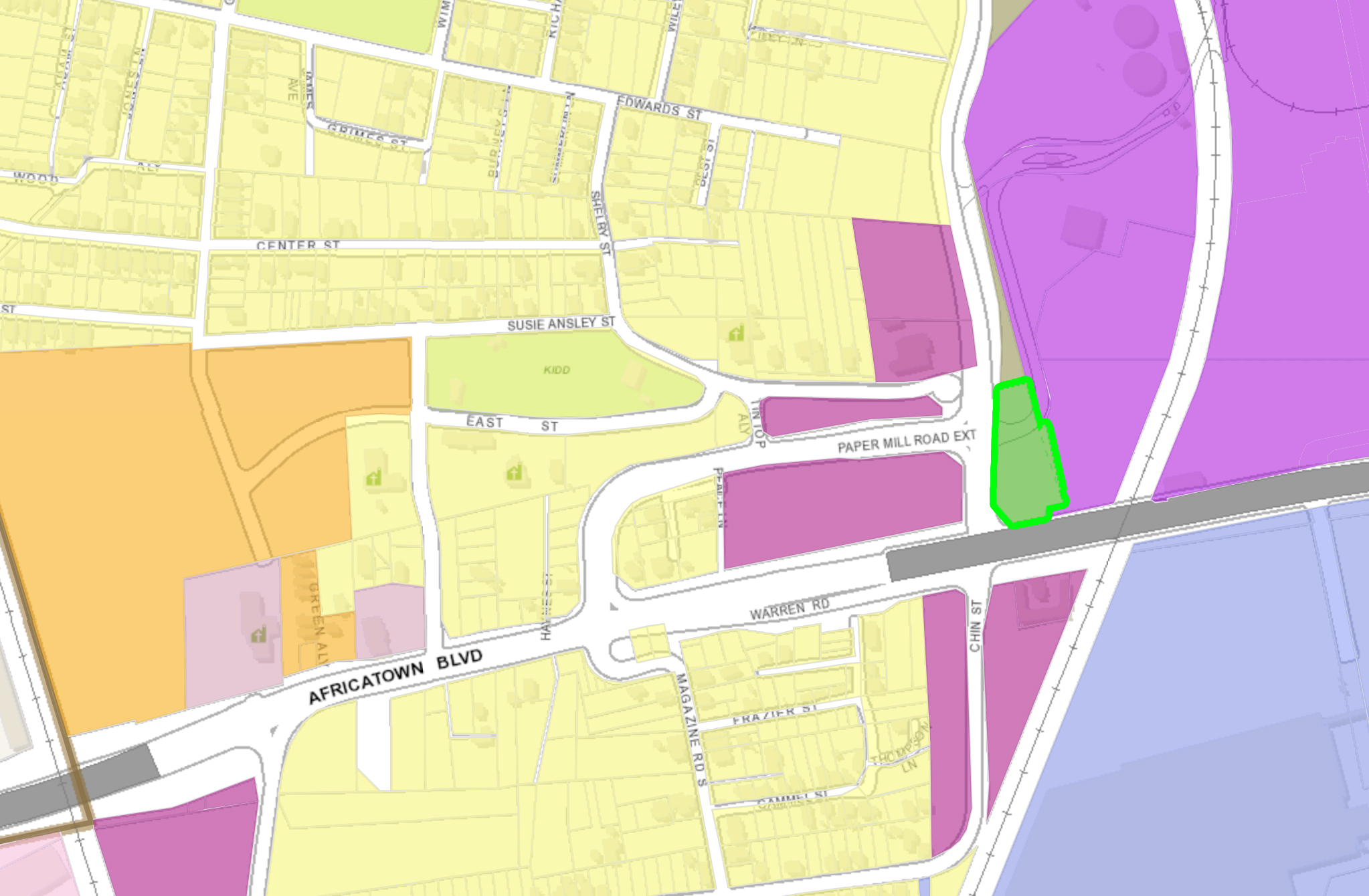
Illustration 12.1 – Reference parcel highlighted green in the proposed UDC composite map
Illustration 12.1 to the right, PropertyID: R022902440002016. (Chippewa Lakes LLC)
This parcel together with R022208440020006.01 (Chippewa Lakes LLC) form the westward border between the Kimberly-Clark Tissue Co paper mill and

Illustration 12.2 – Reference tract highlighted green in the proposed UDC composite map
Paper Mill Road as shown in Illustration 12.2 to the left.
Current zoning of these parcels is mixed across several designations. Along the road underneath the Cochrane-Africatown USA Bridge, the parcel has a Business-2 zoning. Along the southern length of Paper Mill Road, the parcel has a Residential-2 designation. Just north of that, the parcel has an Industrial-2 zoning. The existing zoning for these parcels appears in Illustration 12.3 to the right.

Illustration 12.3 – Reference tract highlighted magenta in the Existing Africatown Zoning composite map
On September 20, 2018, applicants on behalf of Kimberly-Clark Tissue Co, which presumably leases this land from Chippewa Lakes LLC, sought to have all of these parcels rezoned uniformly to an Industrial-2 designation. They tentatively received this designation from the City of Mobile Planning Commission, but the decision was unanimously overturned by the Mobile City Council on November 17, 2018. The rationale for the Council’s decision was stated as being that Kimberly-Clark Tissue Co offered no rationale for the rezoning and failed to hold any community meetings resembling those proposed in UDC Article VI Procedures, Section 64-104 Neighborhood Meetings (p. 198).
To date, neither Kimberly-Clark Tissue Co nor Chippewa Lakes LLC have held any public community meetings conforming to the standards proposed in UDC Article VI Procedures, Section 64-104 Neighborhood Meetings (p. 198) about this parcel.
Current activity on the site suggests that Kimberly-Clark Tissue Co either hasn’t been informed of the City Council’s decision or is ignoring it. The Residential and Business zoned parcels are being used as an equipment staging ground for the $110 million Kimberly-Clark facility expansion despite its zoning designation.
Due to the longstanding, thoroughly documented, and legitimate concerns over losing Residential and Business zoned land to any other designation, some residents, residential stakeholders, and regional advocates would rather see a process that helps actually shed light to residents about any potential plans for the parcels.
Many residents feel deliberately left out of consultative processes rumored to be happening with small groups of residents. While this concern appears to be remedied for future re-zoning planning approval processes in accordance with Article VI Procedures, Section 64-104 Neighborhood Meetings (p. 198), to apply so many changes to a neighborhood in the adoption of a document with many good aspirational goals when so many feel left out of the process of positive change-making in their neighborhood would be a truly wrong foot to start on for the UDC.
As the proposed UDC recognizes, communities deserve to be involved in the development of their neighborhoods. Because political transparency and equitable community participation has been a struggle for some residents in Africatown who have otherwise proven consistently committed to participating in neighborhood planning efforts and also due to the recent heightened community interest around this site, a proper public rezoning hearing after the UDC adoption process may be the best path forward unless those seeking this rezoning hold a neighborhood meeting similar to what is prescribed in Article VI Procedures, Section 64-104 Neighborhood Meetings (p. 198) before the UDC is submitted to the Planning Commission for consideration.
A neighborhood meeting of this nature would help usher the Africatown community closer to the more equitable and inclusive future envisioned by the Africatown Neighborhood Plan.
Parcel Comment 13) Paper Mill Road R1-to-Industrial Heavy Zoning 1

Illustration 13.1 – Reference parcel highlighted green in the proposed UDC composite map
Illustration 13.1 to the right, PropertyID: R022208440013015.12 (Chippewa Lakes LLC)
This parcel is the site of the former Ladd Supply Company warehouses despite its Residential-1 zoning designation. This type of zoning nonconformity is common in this part of the Africatown Planning Area.

Illustration 13.2 – Reference tract highlighted magenta in the Existing Africatown Zoning composite map
The parcel’s existing zoning is shown in Illustration 13.2 to the left.
The warehouse was recently closed and was demolished, which has some residents, residential stakeholders, and regional advocates concerned over possible immediate short-term plans with this property that are not being shared publicly with the neighborhood.
Due to the longstanding, thoroughly documented, and legitimate concerns over losing Residential and Business zoned land to any other designation, some residents, residential stakeholders, and regional advocates would rather see a process that helps actually shed light to residents about any potential plans for the parcels.
Many residents feel deliberately left out of consultative processes rumored to be happening with small groups of residents. While this concern appears to be remedied for future re-zoning planning approval processes in accordance with Article VI Procedures, Section 64-104 Neighborhood Meetings (p. 198), to apply so many changes to a neighborhood in the adoption of a document with many good aspirational goals when so many feel left out of the process of positive change-making in their neighborhood would be a truly wrong foot to start on for the UDC.
As the proposed UDC recognizes, communities deserve to be involved in the development of their neighborhoods. Because political transparency and equitable community participation has been a struggle for some residents in Africatown who have otherwise proven consistently committed to participating in neighborhood planning efforts and also due to the recent heightened community interest around this site, a proper public rezoning hearing after the UDC adoption process may be the best path forward unless those seeking this rezoning hold a neighborhood meeting similar to what is prescribed in Article VI Procedures, Section 64-104 Neighborhood Meetings (p. 198) before the UDC is submitted to the Planning Commission for consideration.
A neighborhood meeting of this nature would help usher the Africatown community closer to the more equitable and inclusive future envisioned by the Africatown Neighborhood Plan.
Parcel Comment 14) Meaher Vacant Land R1-to-Industrial Heavy Rezoning

Illustration 14.1 – Reference parcel highlighted green in the proposed UDC composite map
Illustration 14.1 to the right, PropertyID: R022208440008006. (Augustine Meaher IV)

Illustration 14.2 – Reference tract highlighted green in the proposed UDC composite map
This parcel together with R022208440008005.000. (with an unidentified owner in the City of Mobile’s online GIS software) are proposed to be rezoned in the UDC from Residential-1 to Industrial Heavy. The parcel tract is shown in Illustration 14.2 to the left.
These parcels are completely undeveloped and wooded with trees except for two clearings following the railroad on its eastern edge. Parcels that are vacant and undeveloped do not warrant the most permissive zoning designations afforded by the City of Mobile.

Illustration 14.3 – Reference tract highlighted magenta in the Existing Africatown Zoning composite map
The undeveloped wooded tract’s existing Residential-1 zoning is shown in Illustration 14.3 to the right.
Due to the longstanding, thoroughly documented, and legitimate concerns over losing Residential and Business zoned land to any other designation, some residents, residential stakeholders, and regional advocates would rather see a process that helps actually shed light to residents about any potential plans for the parcels.
Many residents feel deliberately left out of consultative processes rumored to be happening with small groups of residents. While this concern appears to be remedied for future re-zoning planning approval processes in accordance with Article VI Procedures, Section 64-104 Neighborhood Meetings (p. 198), to apply so many changes to a neighborhood in the adoption of a document with many good aspirational goals when so many feel left out of the process of positive change-making in their neighborhood would be a truly wrong foot to start on for the UDC.
As the proposed UDC recognizes, communities deserve to be involved in the development of their neighborhoods. Because political transparency and equitable community participation has been a struggle for some residents in Africatown who have otherwise proven consistently committed to participating in neighborhood planning efforts and also due to the recent heightened community interest around this site, a proper public rezoning hearing after the UDC adoption process may be the best path forward unless those seeking this rezoning hold a neighborhood meeting similar to what is prescribed in Article VI Procedures, Section 64-104 Neighborhood Meetings (p. 198) before the UDC is submitted to the Planning Commission for consideration.
A neighborhood meeting of this nature would help usher the Africatown community closer to the more equitable and inclusive future envisioned by the Africatown Neighborhood Plan.
Parcel Comment 15) Telegraph Road Up-Zonings
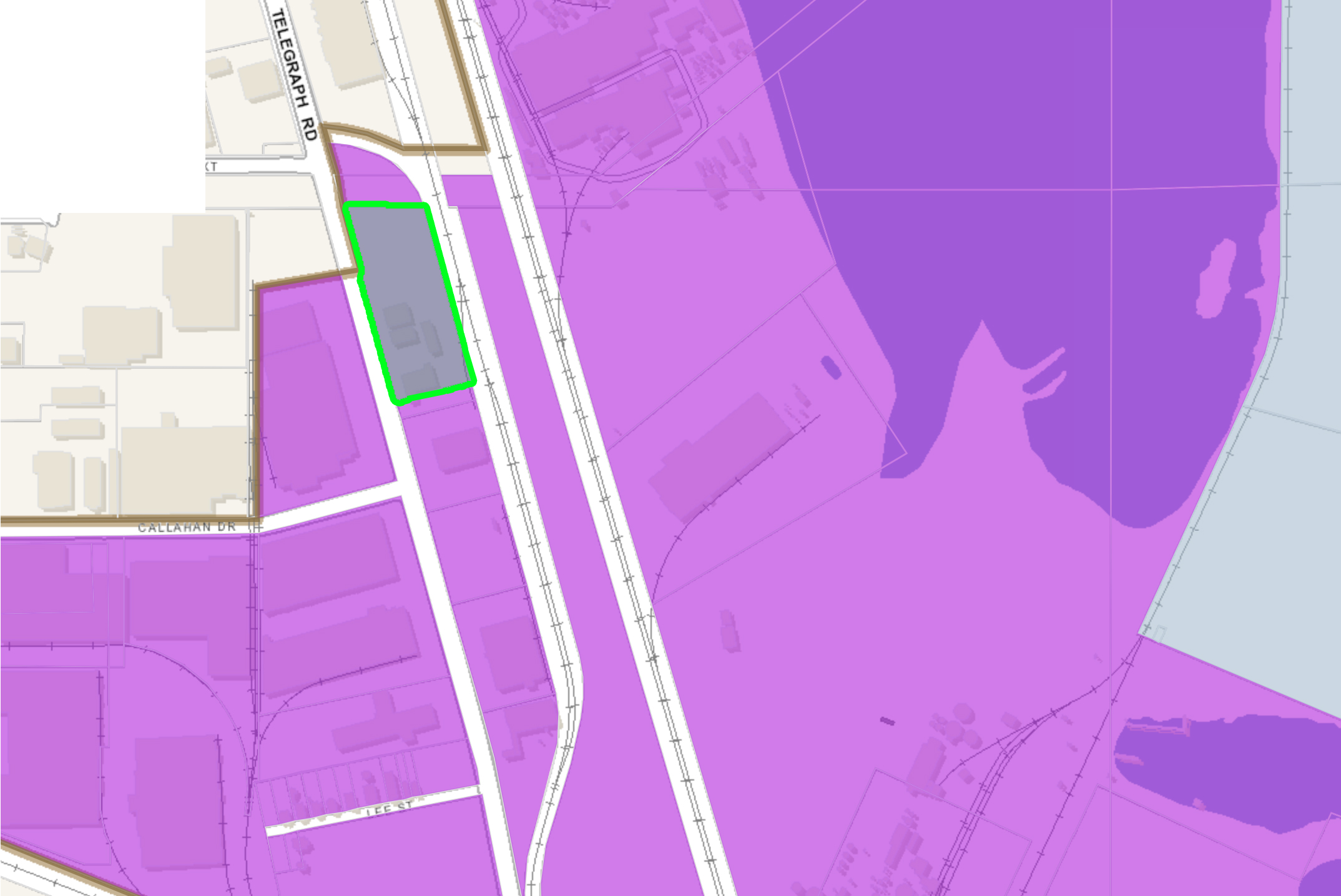
Illustration 15.1 – Reference parcel highlighted green in the proposed UDC composite map
Illustration 15.1 to the right, PropertyID: R022208440008009. (Gulf Supply Co Inc)

Illustration 15.2 – Reference tract highlighted green in the proposed UDC composite map
This parcel together with R022208440003088. (MBW of Alabama Inc) to its north, R022208440008008.000. (unidentified) also to its north, R022208440008010. (Augustine Meaher IV) to its south, R022208440008011. (Tomlinson Investments Inc) to its south, and R022208440008012. (Augustine Meaher IV) to its south form a tract along Telegraph Road in the northwest part of the Africatown Planning Area shown together in Illustration 15.2 to the left.
Each of these parcels are currently zoned as Industrial-1 and are proposed in the UDC to be rezoned as Industrial Heavy. The tract’s current zoning is shown in Illustration 15.3 below and to the right.

Illustration 15.3 – Reference tract highlighted magenta in the Existing Africatown Zoning composite map
The current land use on these parcels, moving from north to south along Telegraph Road includes a training and testing facility, an industrial facility equipment provider, a vacant lot, a transportation services provider, and a parking lot for an industrial cleaning service provider. None of those uses plausibly justifies an Industrial Light zoning, and none of those land uses justify the proposed Industrial Heavy zoning.
A Commercial Warehouse zoning designation would seem to be much more appropriate on these sites unless other uses for the sites are proposed, in which case, the residents of Africatown have opted into engagement around future plans within the Africatown Planning Area and those concerns should be given precedence via the proposed UDC Article VI Procedures, Section 64-104 Neighborhood Meetings (p. 198) before the UDC is submitted to the Planning Commission for consideration.
Parcel Comment 16) Telegraph Road Residential-to-Industrial Rezoning

Illustration 16.1 – Reference parcel highlighted green in the proposed UDC composite map
Illustration 16.1 to the right, PropertyID: R022208440008013. (Energy Asset Management LLC)
This parcel is currently hosts the Turbo Filtration Company, which provides industrial cleaning services with on-site instrument fabrication capacity.

Illustration 16.2 – Reference tract highlighted magenta in the Existing Africatown Zoning composite map
It is currently in nonconformity with its Residential-1 zoning designation, as shown in Illustration 16.2 to the left. This type of zoning nonconformity is common in this part of the Africatown Planning Area.
A zoning designation change to accommodate its current land use is not an unreasonable proposal. This parcel’s on-site instrument fabrication is best described in the proposed UDC Article X Definitions, Section 64-172 Definitions (p. 261-262) as a “Manufacturing, Intensive” land use. The propose UDC Article II Zoning Districts, Section 64-31 Use Table (p. 29) describes “Manufacturing, Intensive” land use as a conditional land use in Industrial Heavy zones. For better or worse, the parcel’s industrial equipment cleaning services doesn’t appear to have a permitted land use in the Use Table definitions.
Due to the erosion that has been perpetrated upon the residential integrity of the Africatown community, any loss of land zoned as Residential makes many uncomfortable, regardless of reason.
A Neighborhood Meeting similar to what is prescribed in Article VI Procedures, Section 64-104 Neighborhood Meetings (p. 198) before the UDC is submitted to the Planning Commission for consideration might be prudent. A meeting of this nature would help usher the Africatown community closer to the more equitable and inclusive future envisioned by the Africatown Neighborhood Plan.
Parcel Comment 17) DPC Residential-to-Industrial Rezoning

Illustration 17.1 – Reference parcel highlighted green in the proposed UDC composite map
Illustration 17.1 to the right, PropertyID: R022208440013009. (Chippewa Lakes LLC)
This tract is actually two parcels, R022208440013009. and R022208440008007., both of which are owned by Chippewa Lakes LLC and both of which are currently zoned Residential-1.
The current land use is by DPC Enterprises, which is a bulk chemical distributor for industrial scale use. It regularly handles chlorine, chlorine bleach, ammonia, and caustic sodas that it receives by rail in bulk then repackages and stores on site for distribution from its facility.

Illustration 17.2 – Reference tract highlighted magenta in the Existing Africatown Zoning composite map
Its current land use appears to be in nonconformity with its current Residential-1 zoning designation, which is shown in Illustration 17.2 to the left. It is also split across jurisdictional boundaries between Prichard and Mobile with the railroad bulk chemical offloading facility entirely within Prichard’s jurisdiction and the on-site containerized chemical storage in Mobile’s. Thus, a zoning designation change to accommodate its current land use is not an unreasonable proposal, however it is unclear which zoning designation is most appropriate because there appears to be no reference to containerized chemical storage in the Article II Zoning Districts, Section 64-31 Use Table (p. 29). That is, unless the definitions for hazardous materials in above ground storage tank farms as conditional land uses under Industrial Heavy zoning are met, but the total storage capacity of this facility is unclear. Of course, under the proposed UDC, these unpermitted and unplanned land uses would be grandfathered as conforming uses.
Which ever designation is shown to be most appropriate, due to the erosion that has been perpetrated upon the residential integrity of the Africatown community, any loss of land zoned as Residential makes many uncomfortable, regardless of reason.
A Neighborhood Meeting similar to what is prescribed in Article VI Procedures, Section 64-104 Neighborhood Meetings (p. 198) before the UDC is submitted to the Planning Commission for consideration might be prudent. A meeting of this nature would help usher the Africatown community closer to the more equitable and inclusive future envisioned by the Africatown Neighborhood Plan.
Parcel Comment 18) Paper Mill Road Vacant Lot R1-to-Industrial Heavy Rezoning

Illustration 18.1 – Reference parcel highlighted green in the proposed UDC composite map
Illustration 18.1 to the right, PropertyID: R022208440013005.000. (Alabama Power Co)
This tract is actually made up of three parcels, R022208440013005.000. (Alabama Power Co), R022208440012006.000. (unidentified), and R022208440012005. (Alabama State Port Authority) all of which are currently zoned as Residential-1 and proposed in the UDC to receive an Industrial Heavy zoning.

Illustration 18.2 – Reference tract highlighted magenta in the Existing Africatown Zoning composite map
Currently this tract of land is completely undeveloped and vacant except for electrical power lines. The existing zoning on this tract is shown in Illustration 18.2 to the left.
Parcels that are vacant and undeveloped do not warrant the most permissive zoning designations afforded by the City of Mobile.
Due to the longstanding, thoroughly documented, and legitimate concerns over losing Residential and Business zoned land to any other designation, some residents, residential stakeholders, and regional advocates would rather see a process that helps actually shed light to residents about any potential plans for the parcels.
Many residents feel deliberately left out of consultative processes rumored to be happening with small groups of residents. While this concern appears to be remedied for future re-zoning planning approval processes in accordance with Article VI Procedures, Section 64-104 Neighborhood Meetings (p. 198), to apply so many changes to a neighborhood in the adoption of a document with many good aspirational goals when so many feel left out of the process of positive change-making in their neighborhood would be a truly wrong foot to start on for the UDC.
As the proposed UDC recognizes, communities deserve to be involved in the development of their neighborhoods. Because political transparency and equitable community participation has been a struggle for some residents in Africatown who have otherwise proven consistently committed to participating in neighborhood planning efforts and also due to the recent heightened community interest around this site, a proper public rezoning hearing after the UDC adoption process may be the best path forward unless those seeking this rezoning hold a neighborhood meeting similar to what is prescribed in Article VI Procedures, Section 64-104 Neighborhood Meetings (p. 198) before the UDC is submitted to the Planning Commission for consideration.
A neighborhood meeting of this nature would help usher the Africatown community closer to the more equitable and inclusive future envisioned by the Africatown Neighborhood Plan.
Parcel Comment 19) A-1 Stop Convenience Store R1-to-Industrial Light Rezoning

Illustration 19.1 – Reference parcel highlighted green in the proposed UDC composite map
Illustration 19.1 to the right, PropertyID: R022208440013221.04 (Chippewa Lakes LLC)

Illustration 19.2 – Reference tract highlighted magenta in the Existing Africatown Zoning composite map
This parcel is currently zoned Residential-1 despite it currently hosting the A-1 Stop convenience store at the corner of Telegraph Road and Woodland Street in Prichard, Alabama and is proposed in the UDC to be rezoned as Industrial Light. The parcel’s existing zoning is shown in Illustration 19.2 to the left.
A convenience store is a nonconforming use in a Residential-1 district, so a zoning designation change to accommodate its current land use is not an unreasonable proposal, but Industrial Light is not an appropriate zoning designation for a convenience store. Instead, a convenience store within the Africatown Planning Area would be more appropriately zoned as Traditional Neighborhood Center.
Due to the erosion that has been perpetrated upon the residential integrity of the Africatown community, any loss of land zoned as Residential makes many uncomfortable, regardless of reason.
A Neighborhood Meeting similar to what is prescribed in Article VI Procedures, Section 64-104 Neighborhood Meetings (p. 198) before the UDC is submitted to the Planning Commission for consideration might be prudent. A meeting of this nature would help usher the Africatown community closer to the more equitable and inclusive future envisioned by the Africatown Neighborhood Plan.
Parcel Comment 20) Metals USA New Zoning Designation

Illustration 20.1 – Reference parcel highlighted green in the proposed UDC composite map
Illustration 20.1 to the right, PropertyID: R022208440013221. (Chippewa Lakes LLC)

Illustration 20.2 – Reference tract highlighted green in the proposed UDC composite map
This parcel together with R022208440013221.03 (Chippewa Lakes LLC) currently hosts a Metals USA metal fabrication facility specializing in plates, structural beams, pressure vessels, pipes and tubing, and more. The second parcel of this tract crosses jurisdictional lines into the City of Prichard from Mobile along Telegraph Road. The two parcels are shown together in Illustration 20.2 to the left.

Illustration 20.3 – Reference tract highlighted magenta in the Existing Africatown Zoning composite map
The existing zoning map suggests that part of the facility is zoned correctly, as “Manufacturing, Intensive” which includes metals fabrication is a conditional use in the proposed UDC Article II Zoning Districts, Section 64-31 Use Table (p. 29). The rest of the property is currently in nonconformity with its Residential-1 zoning designation, as shown in Illustration 20.3 to the right. This type of zoning nonconformity is common in this part of the Africatown Planning Area.
A zoning designation change to accommodate its current land use is not an unreasonable proposal, and the UDC proposed Industrial Light zoning designation appears to be inappropriate for these particular parcels due to the facility’s on-site metals fabrication, which is properly described as “Manufacturing, Intensive” according to the competing definitions of “Manufacturing” types in the proposed UDC Article X Definitions, Section 64-172 Definitions (p. 261-262). “Manufacturing, Intensive” land use is only conditional under Industrial Heavy zoning according to the proposed UDC Article II Zoning Districts, Section 64-31 Use Table (p. 29).
Due to the erosion that has been perpetrated upon the residential integrity of the Africatown community, any loss of land zoned as Residential makes many uncomfortable, regardless of reason.
A Neighborhood Meeting similar to what is prescribed in Article VI Procedures, Section 64-104 Neighborhood Meetings (p. 198) before the UDC is submitted to the Planning Commission for consideration might be prudent. A meeting of this nature would help usher the Africatown community closer to the more equitable and inclusive future envisioned by the Africatown Neighborhood Plan.
Parcel Comment 21) Showers of Blessings Church R1-to-Industrial Rezoning

Illustration 21.1 – Reference parcel highlighted green in the proposed UDC composite map
Illustration 21.1 to the right, PropertyID: R022208440013222. (Church of God Pentecostal Inc)

Illustration 21.2 – Reference tract highlighted green in the proposed UDC composite map
This parcel together with R022208440013221.01 (Church of God Pentecostal Inc) form a tract of land that is split between the Cities of Prichard and Mobile along Telegraph Road. It is proposed in the UDC to be given an Industrial Light zoning designation. The tract is shown together as Illustration 21.2 to the left.

Illustration 21.3 – Reference tract highlighted magenta in the Existing Africatown Zoning composite map
The land currently hosts the Showers of Blessings Church of God in Christ ministry and is zoned today as Residential-1. Churches are regulated in the proposed UDC Use Table as “Religious land use” and are conditional land uses in Residential Low Density. The existing zoning for this tract is shown in Illustration 21.3 to the right.
Because this is a church, the proposed UDC designation of Industrial Light is not appropriate. These parcels should instead be zoned in conformity to the proposed UDC land use standards as any Residential or Commercial/Mixed Use District appropriate for its location east of Interstate 65, such as Residential Low Density or Traditional Neighborhood Center.
Parcel Comment 22) Telegraph Road Vacant Lot R1-Industrial Rezoning

Illustration 22.1 – Reference parcel highlighted green in the proposed UDC composite map
Illustration 22.1 to the right, PropertyID: R022208440013221.002. (Chippewa Lakes LLC)

Illustration 22.2 – Reference tract highlighted magenta in the Existing Africatown Zoning composite map
This parcel is currently an undeveloped vacant lot on Telegraph Road with a daycare center to its south, a church to its north, and a metal fabrication facility to its east. It is proposed in the UDC to receive an Industrial Light zoning designation. The parcel’s existing zoning is shown in Illustration 22.2 to the left.
Parcels that are vacant and undeveloped do not warrant permissive zoning designations from the City of Mobile, and Industrial Light zoning on this site is neither necessary nor consistent with its Telegraph Road public facing neighbors, a daycare center, a church, and a convenience store. A much less intensive zoning designation would be more appropriate like Residential Low Density or Traditional Neighborhood Center.
However, due to the erosion that has been perpetrated upon the residential integrity of the Africatown community, any loss of land zoned as Residential makes many uncomfortable, regardless of reason.
So, should a higher-than-residential designation be settled upon, a Neighborhood Meeting similar to what is prescribed in Article VI Procedures, Section 64-104 Neighborhood Meetings (p. 198) before the UDC is submitted to the Planning Commission for consideration might be prudent. A meeting of this nature would help usher the Africatown community closer to the more equitable and inclusive future envisioned by the Africatown Neighborhood Plan.
Parcel Comment 23) Merchants Transfer Co R1-to-Industrial Rezoning

Illustration 23.1 – Reference parcel highlighted green in the proposed UDC composite map
Illustration 23.1 to the right, PropertyID: R022208440019003. (Alabama Power Co)
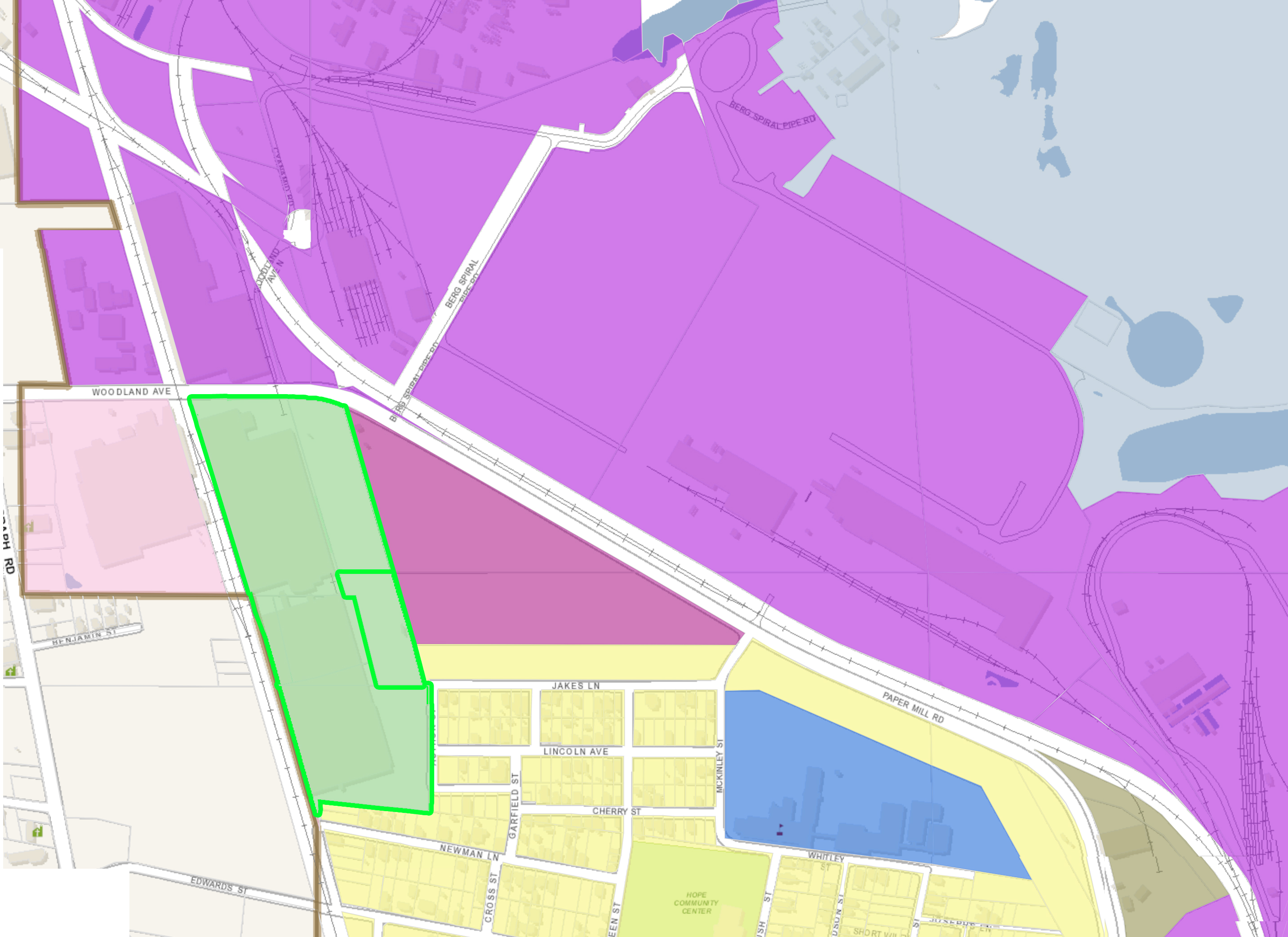
Illustration 23.2 – Reference tract highlighted green in the proposed UDC composite map
This single parcel is currently zoned Residential-1 despite it forming part of a larger tract under the land use of a single entity, Merchants Transfer Company, despite the other parcels having various owners and various existing zoning designations. This parcel forms a contiguous tract that currently hosts Merchants Transfer Company warehouses and tractor trailer parking together with R022208440012008.000. (unidentified) to the north and zoned as Industrial-2, R022208440013226. (Chippewa Lakes LLC) to the northwest and zoned as Industrial-2, R022208440019004. (Woodland Buildings) to the west and zoned as Industrial-2, R022208440018001. (Woodland Buildings) also to the west and zoned as Industrial-2, R022208440019004.001. (Merchants Transfer Co) also to the west and zoned as Industrial-2, and R022208440019005. (Merchants Transfer Co) to the southwest and zoned as Industrial-1. These tracts are shown together in Illustration 23.2 above and to the left.

Illustration 23.3 – Reference tract highlighted green in the proposed UDC composite map
Complicating the situation, Merchants Transfer Company has another warehouse directly across Paper Mill Road on parcel R022208440013006. (Chippewa Lakes LLC) that is proposed in the UDC to receive an Industrial Heavy zoning designation. This parcel is shown with the rest of the Merchants Transfer Company in Illustration 23.3 to the right.
The proposed UDC rezoning for all of the contiguous parcels is to Industrial Light, but that designation doesn’t seem appropriate given that the only activities on site are warehouse storage and distribution related.
A zoning designation for all of the of Commercial Warehouse would presumably be more appropriate than an unnecessarily permissive Industrial Light rezoning.

Illustration 23.4 – Reference tract highlighted magenta in the Existing Africatown Zoning composite map
With respect to the single parcel currently zoned Residential-1, it currently hosts part of a Merchants Transfer Company tractor trailer parking light, so is currently in nonconformity. This type of zoning nonconformity is common in this part of the Africatown Planning Area. The existing zoning for this tract is shown in Illustration 23.4 to the left.
A zoning designation change to accommodate this parcel’s current land use is not an unreasonable proposal. However, due to the erosion that has been perpetrated upon the residential integrity of the Africatown community, any loss of land zoned as Residential makes many uncomfortable, regardless of reason.
A Neighborhood Meeting similar to what is prescribed in Article VI Procedures, Section 64-104 Neighborhood Meetings (p. 198) before the UDC is submitted to the Planning Commission for consideration might be prudent. A meeting of this nature would help usher the Africatown community closer to the more equitable and inclusive future envisioned by the Africatown Neighborhood Plan.
Parcel Comment 24) Miller Transporters Chemical Tank Cleaning Parcel Zoning

Illustration 24.1 – Reference parcel highlighted green in the proposed UDC composite map
Illustration 24.1 to the right, PropertyID: R022208440019440.02 (Miller Bros LLP)

Illustration 24.2 – Reference tract highlighted green in the proposed UDC composite map
This parcel of land is part of a larger tract of four parcels all owned by Miller Bros LLP that currently host the containerized chemical and chemical tanker cleaning facility Miller Transporters Inc.
The three other parcels in this tract include R022208440018327. to its west, R022208440019440.001. to its north, and R022208440018326. to its northwest. The two westward parcels split the jurisdictions of Prichard and Mobile. The parcels are shown together as a tract in Illustration 24.2 above and to the left.

Illustration 24.3 – Reference tract highlighted magenta in the Existing Africatown Zoning composite map
All of the aforementioned parcels are currently zoned Residential-1, as shown in Illustration 24.3 to the right, and their land use is in nonconformity with the City of Mobile’s zoning code. This type of zoning nonconformity is common in this part of the Africatown Planning Area.
A zoning designation change to accommodate this parcel’s current land use is not an unreasonable proposal. However, due to the erosion that has been perpetrated upon the residential integrity of the Africatown community, any loss of land zoned as Residential makes many uncomfortable, regardless of reason.
A Neighborhood Meeting similar to what is prescribed in Article VI Procedures, Section 64-104 Neighborhood Meetings (p. 198) before the UDC is submitted to the Planning Commission for consideration might be prudent. A meeting of this nature would help usher the Africatown community closer to the more equitable and inclusive future envisioned by the Africatown Neighborhood Plan.
Parcel Comment 25) Telecommunications Tower Parcel Zoning

Illustration 25.1 – Reference parcel highlighted green in the proposed UDC composite map
Illustration 25.1 to the right, PropertyID: R022208440018326.001. (unidentified) & R022208440019440.002. (unidentified)
This tract of land splits jurisdiction between Prichard and Mobile. The Mobile side of the jurisdictional boundaries is undeveloped and wooded land. There is one building on the Prichard side and a telecommunications tower that appears connected to the building.

Illustration 25.2 – Reference tract highlighted magenta in the Existing Africatown Zoning composite map
Both parcels in the tract are currently zoned as Residential-1, as shown in Illustration 25.2 to the left. The proposed UDC designation for both parcels is Residential Low Density, which may be appropriate for the R022208440019440.002. parcel which is the furthest east of the two parcels along the railroad tracks and is entirely within the City of Mobile. R022208440018326.001., the second parcel in this tract that splits jurisdiction between Prichard and Mobile, hosts a telecommunications tower and telecommunications towers are an expressly prohibited land use in Residential Low Density zones according to the proposed UDC Article V Use Regulations, Section 64-84 Telecommunications Facilities (p. 182).
Thus, a zoning designation change to accommodate this parcel’s current land use is not an unreasonable proposal. However, due to the erosion that has been perpetrated upon the residential integrity of the Africatown community, any loss of land zoned as Residential makes many uncomfortable, regardless of reason.
A Neighborhood Meeting similar to what is prescribed in Article VI Procedures, Section 64-104 Neighborhood Meetings (p. 198) before the UDC is submitted to the Planning Commission for consideration might be prudent. A meeting of this nature would help usher the Africatown community closer to the more equitable and inclusive future envisioned by the Africatown Neighborhood Plan.
Parcel Comment 26) Transouth Holdings LLC Partially Vacant Parcel Zoning

Illustration 26.1 – Reference parcel highlighted green in the proposed UDC composite map
Illustration 26.1 to the right, PropertyID: R022208440018325. (Transouth Holdings LLC)

Illustration 26.2 – Reference tract highlighted magenta in the Existing Africatown Zoning composite map
This parcel splits jurisdictional boundaries between Prichard and Mobile and currently hosts an abandoned building on its Prichard side that faces Telegraph Road. The area of the parcel in the City of Mobile is undeveloped and wooded land along the railroad to the property’s eastern most side. The parcel is currently zoned as Residential-1, as shown in Illustration 26.2 to the left.
The parcel is proposed in the UDC to receive a Residential Low Density designation, and given the land use on the rest of the property, that may be appropriate considering it only hosts an abandoned commercial building. A zoning designation change to accommodate this parcel’s apparent defunct land use is not an unreasonable proposal, but due to the erosion that has been perpetrated upon the residential integrity of the Africatown community, any loss of land zoned as Residential makes many uncomfortable, regardless of reason.
A Neighborhood Meeting similar to what is prescribed in Article VI Procedures, Section 64-104 Neighborhood Meetings (p. 198) before the UDC is submitted to the Planning Commission for consideration might be prudent. A meeting of this nature would help usher the Africatown community closer to the more equitable and inclusive future envisioned by the Africatown Neighborhood Plan.
Parcel Comment 27) Cemex Bulk Cement Distribution Zoning

Illustration 27.1 – Reference parcel highlighted green in the proposed UDC composite map
Illustration 27.1 to the right, PropertyID: R022902440003038. (Southern Railroad Co)

Illustration 27.2 – Reference tract highlighted magenta in the Existing Africatown Zoning composite map
This parcel has split jurisdiction between Prichard and Mobile and currently hosts a rail terminal and what is presumably a wholesale distribution point for the concrete and cement manufacturing company Cemex. Almost all of the site is in the City of Prichard with just a sliver in Mobile. The parcel is currently zoned a Residential-1 as shown in Illustration 27.2 to the left. This type of zoning nonconformity is common in this part of the Africatown Planning Area.
The proposed UDC zoning is Residential Low Density, but given the parcel’s likely current land use as a wholesale distribution point for “building and landscaping materials” or as “freight depot (railway and truck)”, a designation as a Commercial Warehouse is not an unreasonable proposal. According to the proposed UDC Article II Zoning Districts, Section 64-31 Use Table (p. 26), Commercial Warehouse would permit both possible land use types. However, due to the erosion that has been perpetrated upon the residential integrity of the Africatown community, any loss of land zoned as Residential makes many uncomfortable, regardless of reason.
A Neighborhood Meeting similar to what is prescribed in Article VI Procedures, Section 64-104 Neighborhood Meetings (p. 198) before the UDC is submitted to the Planning Commission for consideration might be prudent. A meeting of this nature would help usher the Africatown community closer to the more equitable and inclusive future envisioned by the Africatown Neighborhood Plan.
Parcel Comment 28) International Paper Utility and Railroad Easement Parcels

Illustration 28.1 – Reference parcel highlighted green in the proposed UDC composite map
Illustration 28.1 to the right, PropertyID: R022208440013227. (International Paper Co) & R022208440013003.01 (International Paper Co)

Illustration 28.2 – Reference tract highlighted magenta in the Existing Africatown Zoning composite map
These adjacent parcels are part of a small tract of land that is owned by International Paper Company. They currently host a railroad easement and an Alabama Power electrical utility easement. Otherwise, they are vacant and undeveloped. They are both currently zoned as Industrial-2, as shown in Illustration 28.2 to the left.
Parcels that are vacant and undeveloped do not warrant permissive zoning designations from the City of Mobile. The UDC proposes an Industrial Heavy zoning for these parcels, but given the active transportation and utility easements that dominate these parcels, any other practical land use is unimaginable. High power electrical transmission lines are defined as “Minor Utility” land use in the proposed UDC Article X Definitions, Section 64-172 (p. 264) and “Minor Utility” land use is permitted in Public-Instutitional zoning designations in the proposed UDC Article II Zoning Districts, Section 64-31 Use Table (p. 29). Given the practical restrictions on their land use possibilities, a Public-Institutional zoning designation would be more appropriate than Industrial Heavy for these parcels.
Parcel Comment 29) Gulf City Shell Corporation R1-to-Industrial Rezoning

Illustration 29.1 – Reference parcel highlighted green in the proposed UDC composite map
Illustration 29.1 to the right, PropertyID: R022208440013015. (Chippewa Lakes)
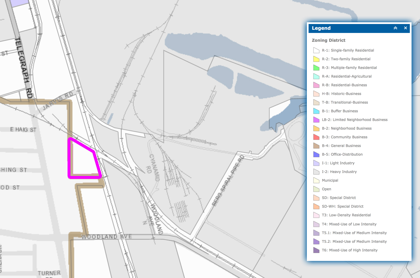
Illustration 29.2 – Reference tract highlighted magenta in the Existing Africatown Zoning composite map
This parcel has its jurisdiction split between the City of Prichard and City of Mobile. It is currently zoned as Residential-1 as shown in Illustration 29.2 to the left. The current land use on the Mobile side of the parcel appears to be a “building and landscaping materials” distribution center operated by Gulf City Shell Corporation. The Prichard side hosts an administrative building for Gulf City Shell Corporation and what appears to be a large vacant warehouse, which may actually be part of Gulf City Shell Corporation, as well, but is unlabeled. “Building and landscaping materials” distribution is not conforming with its current Residential-1 zoning designation. This type of zoning nonconformity is common in this part of the Africatown Planning Area.
The proposed UDC zoning is Industrial Heavy, but given the parcel’s current land use as a wholesale distribution point for “building and landscaping materials”, a designation as a Commercial Warehouse is a much more appropriate zoning designation than either Residential Low Density or Industrial Heavy. However, due to the erosion that has been perpetrated upon the residential integrity of the Africatown community, any loss of land zoned as Residential makes many uncomfortable, regardless of reason.
A Neighborhood Meeting similar to what is prescribed in Article VI Procedures, Section 64-104 Neighborhood Meetings (p. 198) before the UDC is submitted to the Planning Commission for consideration might be prudent. A meeting of this nature would help usher the Africatown community closer to the more equitable and inclusive future envisioned by the Africatown Neighborhood Plan.
Parcel Comment 30) Alabama Power Minor Utility and Utility Easement Tract

Illustration 30.1 – Reference parcel highlighted green in the proposed UDC composite map
Illustration 30.1 to the right, PropertyID: R022208440013003.001. (Alabama Power Company)

Illustration 30.2 – Reference tract highlighted green in the proposed UDC composite map
This parcel forms a tract with two others to its immediate north and south that hosts a large Alabama Power electrical substation and adjacent high power electrical utility as well as transmission pipeline easements. The tract together is shown in Illustration 30.2 to the left. The other two parcels in this tract are both owned by the State of Alabama and are identified as R022208440013003.002. to the north and R022208440013003. to the south.

Illustration 30.3 – Reference tract highlighted magenta in the Existing Africatown Zoning composite map
The existing parcels are currently zoned as Industrial-2 as shown in Illustration 30.3 to the right. The proposed UDC zoning is Industrial Heavy, but given that there is no other practical use for any of these properties given the size of the electrical utility easements that traverse them and the existence of transmission pipeline easements, a Public-Institutional zoning designation for its “Minor Utility” land use is much more appropriate.
Parcel Comment 31) Former Multisorb Technologies Warehouse and Refinery Site

Illustration 31.1 – Reference parcel highlighted green in the proposed UDC composite map
Illustration 31.1 to the right, PropertyID: R022208440008003. (Merchants Transfer Company)

Illustration 31.2 – Reference tract highlighted magenta in the Existing Africatown Zoning composite map
This parcel is the site of the former Multisorb Technologies warehouse and refinery. It was purchased by Merchants Transfer Company, a commercial warehouse and distribution company. It’s current zoning is Industrial-2, as shown in Illustration 31.2 to the left.
The parcel is proposed in the UDC to receive an Industrial Heavy zoning, but unless there are other designs for the large warehouse facility on site, it will be operated as a large commercial warehouse and would be better given a designation of Commercial Warehouse, similar to the recommended designation MEJAC has given for Merchants Transfer Company’s other warehouses in the Africatown Planning Area.
Parcel Comment 32) Terminal Railroad Spur Easement Parcels

Illustration 32.1 – Reference tract highlighted green in the proposed UDC composite map
Illustration 32.1 to the right, PropertyID: R022208440020002.01 (Alabama State Port Authority), R022208440020002. (Alabama State Port Authority), and R022208440020003. (Alabama State Port Authority)

Illustration 32.2 – Reference tract highlighted magenta in the Existing Africatown Zoning composite map
This tract is comprised of three parcels owned by Alabama State Port Authority that currently host a spur from the Terminal Railroad servicing Berg Pipe Mobile Corp and are otherwise vacant. This tract is currently zoned as Industrial-2 as shown in Illustration 32.2 to the left.
Parcels that are vacant and undeveloped do not warrant overly permissive zoning designations from the City of Mobile. The UDC proposes an Industrial Heavy zoning for these parcels, but given the active transportation easement and otherwise vacancy of these parcels, a different and less permissive zoning such as Commercial Warehouse would be more appropriate.
Parcel Comment 33) Olivet Church R1-to-Industrial Light Rezoning

Illustration 33.1 – Reference parcel highlighted green in the proposed UDC composite map
Illustration 33.1 to the right, PropertyID: R022902440018009. (Olivet Missionary Baptist)

Illustration 33.2 – Reference parcel highlighted magenta in the Existing Africatown Zoning composite map
This parcel currently hosts the Olivet Missionary Baptist Church and is currently designated as a Residential-1 zoning, as shown in Illustration 33.2 to the left.
It is proposed in the UDC to be given an Industrial Light zoning designation. Churches are regulated in the proposed UDC Use Table as “Religious land use” and are conditional land uses in Residential Low Density.
Because this parcel currently hosts a church, and given its proximity to the Mobile Housing Authority’s former Josephine Allen public housing site, and the critical need to attract residential investment back into the community as identified in the Africatown Neighborhood Plan, the proposed UDC designation of Industrial Light is not appropriate. This parcel should instead be zoned in conformity to the proposed UDC land use standards as any Residential or Commercial/Mixed Use District appropriate for its location east of Interstate 65, such as Residential Low Density, Residential Mixed, or Traditional Neighborhood Center.
However, due to the erosion that has been perpetrated upon the residential integrity of the Africatown community, any loss of land zoned as Residential makes many uncomfortable, regardless of reason.
Should a designation other than Residential be ultimately settled upon, a Neighborhood Meeting similar to what is prescribed in Article VI Procedures, Section 64-104 Neighborhood Meetings (p. 198) before the UDC is submitted to the Planning Commission for consideration might be prudent. A meeting of this nature would help usher the Africatown community closer to the more equitable and inclusive future envisioned by the Africatown Neighborhood Plan.
Parcel Comment 34) Henry J Reid Fire Station Zoning

Illustration 34.1 – Reference parcel highlighted green in the proposed UDC composite map
Illustration 34.1 to the right, PropertyID: R022902440018008. (City of Mobile)

Illustration 34.2 – Reference parcel highlighted magenta in the Existing Africatown Zoning composite map
This parcel currently hosts the City of Mobile’s Henry J Reid Fire Station and is currently zoned as Industrial-1, as shown in Illustration 34.2 to the left.
The proposed UDC zoning for this parcel is Industrial Light. According to the proposed UDC Article II Zoning Districts, Section 64-31 Use Table (p. 26, 28), “Public Safety Facilities” are permitted in every zoning designation provided by the city except for Residential Low Density and Residential Mixed, where it is a conditional land use.
Given its proximity to the Mobile Housing Authority’s former Josephine Allen public housing site, and the critical need to attract residential investment back into the community as identified in the Africatown Neighborhood Plan, maintaining the fire station’s current Industrial zoning when other designations could allow for greater flexibility in the future seems unnecessary. A zoning designation of Traditional Neighborhood Center or Traditional Corridor would be more appropriate.
Parcel Comment 35) Heavy Equipment Rental and Storage Facility Zoning

Illustration 35.1 – Reference parcel highlighted green in the proposed UDC composite map
Illustration 35.1 to the right, PropertyID: R022902440018016. (Walter C Ernest III)

Illustration 35.2 – Reference parcel highlighted magenta in the Existing Africatown Zoning composite map
This parcel currently hosts what appears to be a facility for a “heavy construction equipment dealer”, “machinery and heavy equipment sales and service”, or “outdoor storage” likely for Ernest Construction LLC. It is currently zoned Industrial-2, as shown in Illustration 35.2 to the left.
The proposed UDC designation is Industrial Light. According to the proposed UDC Article II Zoning Districts, Section 64-31 Use Table (p. 26, 28), “heavy construction equipment dealers”, “machinery and heavy equipment sales and service”, and “outdoor storage” are all permitted uses in Commercial Warehouse, Industrial Light, and Industrial Heavy zoning designations.
Given its proximity to the Mobile Housing Authority’s former Josephine Allen public housing site, and the critical need to attract residential investment back into the community as identified in the Africatown Neighborhood Plan, maintaining this parcel’s current Industrial zoning when other designations could allow for greater and more attractive residential-serving flexibility in the future seems unnecessary. A zoning designation of Commercial Warehouse would be more appropriate and befitting of its current use than either Industrial designation.
Parcel Comment 36) Gulf Coast Marine Supply Industrial Zoning

Illustration 36.1 – Reference tract highlighted green in the proposed UDC composite map
Illustration 36.1 to the right, PropertyIDs: R022902440018011. and R022902440018012. (Gulf Coast Marine Supply)

Illustration 36.2 – Reference tract highlighted magenta in the Existing Africatown Zoning composite map
This tract is composed of two parcels which both currently host the warehouse supplier of quality pipe, valves, fittings, instrumentation, industrial mill supplies, actuation, hose and gasketing known as Gulf Coast Marine Supply, which also owns the parcels. Both parcels are currently zoned Industrial-2, as shown in Illustration 36.2 to the left.
The proposed UDC zoning designation for these parcels is split between R022902440018011. receiving an Industrial Light designation and R022902440018012. receiving a Maritime Light designation. The current land use on both sites can be best described as “wholesale distribution, warehousing and storage”, which according to the proposed UDC Article II Zoning Districts, Section 64-31 Use Table (p. 26, 28), is a permitted use in Commercial Warehouse, Maritime Light, Maritime Heavy, Industrial Light, and Industrial Heavy zoning designations.
Given its proximity to the Mobile Housing Authority’s former Josephine Allen public housing site, and the critical need to attract residential investment back into the community as identified in the Africatown Neighborhood Plan, maintaining this tracts’ current Industrial zoning when other designations could allow for greater and more attractive residential-serving flexibility in the future seems unnecessary. A zoning designation of Commercial Warehouse would be more appropriate and befitting of its current use than any Maritime or Industrial designation.
Parcel Comment 37) Vacant Parcel Telegraph Road Zoning

Illustration 37.1 – Reference parcel highlighted green in the proposed UDC composite map
Illustration 37.1 to the right, PropertyID: R022902440018007. (Chippewa Lakes LLC)

Illustration 37.2 – Reference parcel highlighted magenta in the Existing Africatown Zoning composite map
This parcel is currently a vacant lot on Telegraph Road. It’s current zoning designation is Industrial-1, as shown in Illustration 37.2 to the left.
The proposed UDC zoning designation for this parcel is Industrial Light, but parcels that are vacant and undeveloped do not warrant permissive zoning designations from the City of Mobile. Also given its proximity to the Mobile Housing Authority’s former Josephine Allen public housing site, and the critical need to attract residential investment back into the community as identified in the Africatown Neighborhood Plan, maintaining this tracts’ current Industrial zoning when other designations could allow for greater and more attractive residential-serving flexibility in the future seems unnecessary.
An Industrial Light zoning on this site is neither necessary nor consistent with its Telegraph Road public facing neighbors, which MEJAC feels should be zoned in the UDC as Commercial Warehouse. A Commercial Warehouse designation on this parcel is a much more appropriate application of the city’s zoning discretion.
Parcel Comment 38) B & B Industrial Supply Zoning

Illustration 38.1 – Reference tract highlighted green in the proposed UDC composite map
Illustration 38.1 to the right, PropertyIDs: R022902440018006. (B & B Industrial Supply Co) and R022902440003199. (Bay Bridge Properties Inc)

Illustration 38.2 – Reference tract highlighted magenta in the Existing Africatown Zoning composite map
These parcels together form a tract which currently hosts the commercial plumbing fittings, valves, and pipe warehouse B & B Industrial Supply. The tracts existing zoning is Industrial-1, which is shown in Illustration 38.2 to the left.
The proposed UDC zoning designation is Industrial Light. However, given its proximity to the Mobile Housing Authority’s former Josephine Allen public housing site, and the critical need to attract residential investment back into the community as identified in the Africatown Neighborhood Plan, maintaining this parcel’s current Industrial zoning when other designations could allow for greater and more attractive residential-serving flexibility in the future seems unnecessary. A zoning designation of Commercial Warehouse would be more appropriate and befitting of its current use than any Industrial designation.
Parcel Comment 39) Young Transport Zoning

Illustration 39.1 – Reference parcel highlighted green in the proposed UDC composite map
Illustration 39.1 to the right, PropertyID: R022902440003198. (Bay Bridge Properties Inc)

Illustration 39.2 – Reference parcel highlighted magenta in the Existing Africatown Zoning composite map
This parcel currently hosts the tractor trailer servicing and dispatch carrier company Young Transport LLC. Its current zoning is designated as Industrial-1, as shown in Illustration 39.2 to the left.
The proposed UDC zoning designation for this parcel is Industrial Light, and while the land use as a place of commercial “truck repair” is permitted under Industrial Light and Industrial Heavy designations, it is also permitted under the less permissive and more appropriate Commercial Warehouse designation.
Given its proximity to the Mobile Housing Authority’s former Josephine Allen public housing site, and the critical need to attract residential investment back into the community as identified in the Africatown Neighborhood Plan, maintaining this parcel’s current Industrial zoning when other designations could allow for greater and more attractive residential-serving flexibility in the future seems unnecessary. A zoning designation of Commercial Warehouse would be more appropriate and befitting of its current use than any Industrial designation.
Parcel Comment 40) Vacant Lot Telegraph Road Zoning

Illustration 40.1 – Reference parcel highlighted green in the proposed UDC composite map
Illustration 40.1 to the right, PropertyID: R022902440003197. (Bay Bridge Properties Inc)

Illustration 40.2 – Reference parcel highlighted magenta in the Existing Africatown Zoning composite map
This parcel currently hosts a fenced parking lot with exclusive ingress from the Young Transport LLC property to its immediate south. The parcel is currently zoned as Residential-2, as shown in Illustration 40.2 to the left. According to the proposed UDC Article II Zoning Districts, Section 64-31 Use Table (p. 29), “parking facilities” are not permitted uses in any Residential zoning. This kind of land use nonconformity is common the Africatown Planning Area.
A zoning designation change to accommodate this parcel’s apparent land use is not an unreasonable proposal. However, due to the erosion that has been perpetrated upon the residential integrity of the Africatown community, any loss of land zoned as Residential makes many uncomfortable, regardless of reason.
A Neighborhood Meeting similar to what is prescribed in Article VI Procedures, Section 64-104 Neighborhood Meetings (p. 198) before the UDC is submitted to the Planning Commission for consideration might be prudent. A meeting of this nature would help usher the Africatown community closer to the more equitable and inclusive future envisioned by the Africatown Neighborhood Plan.
Furthermore, the UDC proposed Industrial Light zoning for this parcel is overly permissive for the sites function as a place of commercial “truck repair”. While that land use is permitted under Industrial Light and Industrial Heavy designations, it is also permitted under the less permissive and more appropriate Commercial Warehouse designation.
Given its proximity to the Mobile Housing Authority’s former Josephine Allen public housing site, and the critical need to attract residential investment back into the community as identified in the Africatown Neighborhood Plan, maintaining this parcel’s current Industrial zoning when other designations could allow for greater and more attractive residential-serving flexibility in the future seems unnecessary. A zoning designation of Commercial Warehouse would be more appropriate and befitting of its current use than any Industrial designation.
Parcel Comment 41) Telegraph Road Vacant Tract B2-to-Industrial Rezoning

Illustration 41.1 – Reference tract highlighted green in the proposed UDC composite map
Illustration 41.1 to the right, PropertyIDs: R022902440003056.01 and R022902440003056. (Virginia Bryant)

Illustration 41.2 – Reference tract highlighted magenta in the Existing Africatown Zoning composite map
These two parcels together form a tract of land that is currently vacant and undeveloped. Their current zoning designation is Business-2, as is shown in Illustration 41.2 to the left.
The proposed UDC zoning designation for these parcels is Industrial Light, but given its proximity to the Mobile Housing Authority’s former Josephine Allen public housing site and the Happy Hills community along Chin Street, as well as the critical need to attract residential investment back into the community as identified in the Africatown Neighborhood Plan, changing this parcel’s current Business zoning to Industrial Light when other designations could allow for greater and more attractive residential-serving flexibility in the future seems unnecessary. A zoning designation of Traditional Neighborhood Center would be more appropriate and befitting of its current designation and plausible resident-oriented services offered in the future on the site than any Industrial designation.
Parcel Comment 42) Telegraph Road Vacant Parcel Zoning

Illustration 42.1 – Reference parcel highlighted green in the proposed UDC composite map
Illustration 42.1 to the right, PropertyID: R022902440018004. (Chippewa Lakes LLC)

Illustration 42.2 – Reference parcel highlighted magenta in the Existing Africatown Zoning composite map
This parcel is currently vacant with a couple shrubs and a tree while most of the property is covered with various aggregate surfaces. The parcel is currently zoned as Industrial-1, as shown in Illustration 42.2 to the left.
The proposed UDC zoning designation is Industrial Light, but parcels that are vacant and undeveloped do not warrant overly permissive zoning designations from the City of Mobile. Also given its proximity to the Mobile Housing Authority’s former Josephine Allen public housing site and the Happy Hills and Magazine Point communities along Chin Street, as well as the critical need to attract residential investment back into the community as identified in the Africatown Neighborhood Plan, maintaining this tracts’ current Industrial zoning when other designations could allow for greater and more attractive residential-serving flexibility in the future seems unnecessary.
An Industrial Light zoning on this site is neither necessary nor consistent with its Telegraph Road public facing neighbors, which MEJAC feels should be zoned in the UDC as Commercial Warehouse. A Commercial Warehouse designation on this parcel is a much more appropriate application of the city’s zoning discretion.
Parcel Comment 43) Lift Parts Service Company Inc Zoning

Illustration 43.1 – Reference parcel highlighted green in the proposed UDC composite map
Illustration 43.1 to the right, PropertyID: R022902440003194. (D & M LLC)

Illustration 43.2 – Reference parcel highlighted magenta in the Existing Africatown Zoning composite map
This parcel currently hosts the hydraulic system repair shop Lift Parts Service Company Inc. The parcel’s current zoning designation is Industrial-1, as shown in Illustration 43.2 to the left.
The proposed UDC zoning designation for the parcel is Industrial Light, and while the land use as a place of commercial “machinery and heavy equipment sales and service” is permitted under Industrial Light and Industrial Heavy designations, it is also permitted under the less permissive and more appropriate Commercial Warehouse designation.
Given its proximity to the Mobile Housing Authority’s former Josephine Allen public housing site, and the critical need to attract residential investment back into the community as identified in the Africatown Neighborhood Plan, maintaining this parcel’s current Industrial zoning when other designations could allow for greater and more attractive residential-serving flexibility in the future seems unnecessary. A zoning designation of Commercial Warehouse would be more appropriate and befitting of its current use than any Industrial designation.
Parcel Comment 44) Vacant Alabama MHMR Lot Zoning

Illustration 44.1 – Reference parcel highlighted green in the proposed UDC composite map
Illustration 44.1 to the right, PropertyID: R022902440003188. (Alabama Department of Mental Health & Mental Retardation)

Illustration 44.2 – Reference parcel highlighted magenta in the Existing Africatown Zoning composite map
This parcel is currently vacant, wooded, and undeveloped except for a rail spur that crosses its property to service the Hosea O Weaver asphalt facility across Bay Bridge Cutoff Road. The parcel’s current zoning is Industrial-2, as shown in Illustration 44.2 to the left.
The proposed UDC zoning designation for this parcel is Industrial Light, but parcels that are vacant and undeveloped do not warrant permissive zoning designations from the City of Mobile. Also given its immediate proximity to homes along Chin Street in the Magazine Point neighborhood and the critical need to attract residential investment back into the community as identified in the Africatown Neighborhood Plan, maintaining this tracts’ current Industrial zoning when other designations could allow for greater and more attractive residential-serving flexibility in the future seems unnecessary.
A Commercial Warehouse designation on this parcel is a much more judicious application of the city’s zoning discretion.
Parcel Comment 45) Vacant MAWSS Lot on Telegraph Road Rezoning

Illustration 45.1 – Reference parcel highlighted green in the proposed UDC composite map
Illustration 45.1 to the right, PropertyID: R022902440003068. (Board of Water and Sewer Commissioners of the City of Mobile)

Illustration 45.2 – Reference parcel highlighted magenta in the Existing Africatown Zoning composite map
This parcel is currently vacant and undeveloped except for what is presumably a MAWSS easement of some sort. The parcel’s current zoning designation is Industrial-1, as shown in Illustration 45.2 to the left.
The proposed UDC zoning designation for this parcel is Industrial Light, but parcels that are vacant and undeveloped do not warrant permissive zoning designations from the City of Mobile. Given the critical need to attract residential investment back into the community as identified in the Africatown Neighborhood Plan, maintaining this tracts’ current Industrial zoning when other designations could allow for greater and more attractive residential-serving flexibility in the future seems unnecessary.
Such possibility would be for the parcel to serve as a walking path connecting the future Africatown Welcome Center site just opposite the parcel across the railroad tracks to the Happy Hills neighborhood. In that case, a Traditional Neighborhood Center or Residential zoning of some sort would be appropriate for this parcel.
Code Comment 1) Conservation Subdivision Standards
Article II Composite Standards, Section 64-43 Site Design, D, 1 (p. 52-56):
The Conservation Subdivision standard is overall a positive and welcome development, however, it is disappointing that its mandatory scope is so unnecessarily limited to just the Peninsula of Mobile.
To increase its positive impacts on our urban environment, the design standard should be mandatory for at least all properties subject to the Riparian Buffer standard in the Article IV Development Standards, Section 64-59 Natural Resource Protection, C (p.114). The Riparian Buffer standard itself should also apply more broadly, and MEJAC addresses those concerns in a separate comment on that standard.
Click here to add your comment about this proposed section of the UDC.
Code Comment 2) Public Tree Removal Authority
The value of trees in urban settings cannot be overstated, and Mobile is very fortunate to have a canopy that is both beautiful and abundant. Some of the existing regulations regarding the removal of public trees along public rights of way has been described as cumbersome, so a balance should be struck between the interests of those wanting to more quickly and decisively remove trees for construction purposes and those who recognize that trees are both valuable and nearly impossible to replace in the immediate term.
Some careful consideration has been given to those needs in this provision, but it is concerning that the Director of Planning would be given total discretionary authority over arborists whose expertise is indisputable. If removing the Tree Commission’s authority from the deliberative process for removing public trees altogether is the goal, then for the Director’s sake, a tree removal permit should at least require consultation with the Tree Commission’s urban forester to ensure the Director is able to make an informed decision.
Click here to add your comment about this proposed section of the UDC.
Code Comment 3) Tree Removal Permitting Process
Article IV Development Standards, Section 64-56 Landscaping & Tree Preservation, 5, (c) (p. 102):
The proposed UDC “permit procedure” for the removal of public trees provides just ten working days for the permit to be adjudicated after which point if a decision hasn’t been rendered, the request to remove public trees would be automated granted.
Construction projects rarely hinge on ten day windows. The workload of the Director and any potential consultation with the City of Mobile’s urban forester may not allow for a full visitation of the facts of a permit in a ten day window. Thus the window should be extended to accommodate an appropriate, fully informed consultation with the urban forester and any administrative deadline should trigger a permit denial instead of approval.
Click here to add your comment about this proposed section of the UDC.
Code Comment 4) Industrial/Residential District Buffer Standards
Article IV Development Standards, Section 64-57 Buffers (p. 108):
This proposed UDC buffer standard is being carried over more or less intact from the existing zoning code. For the most part, these standards are appropriate. However, in some cases commonly permitted activities in Industrial, Maritime, and Commercial-Warehouse districts are noisy, unsightly, or cause burdensome amounts of fugitive dust and other debris from their properties. In those circumstances, the existing six foot wall or fence requirement is inadequate in that it will not prevent these kinds of trespasses upon neighboring properties, some of which are residential in nature.
This buffer standard should be refined to account for these predictable kinds of impacts with a higher standard not allowing for chain link fencing but requiring an aesthetically respectful wall meeting a higher minimum height of at least ten feet.
Augmenting the Screen Planting Strip standards to a ten foot height would be appropriate along with the other existing Screen Planting Strip standards, as well.
Click here to add your comment about this proposed section of the UDC.
Code Comment 5) Riparian Buffers Standard Applicability
Article IV Development Standards, Section 64-59 Natural Resource Protection, C, 1, (a) (p.115):
The proposed UDC Riparian Buffer standards are overall a positive and welcome development, however, it is disappointing that its mandatory scope is limited to “parcels of five acres or greater with proposed subdivision of land containing or abutting water bodies subject to the protection standards of this section”.
Five acres of land is 24,200 square yards or almost four NFL regulation football fields complete with end zones, which is more land than one might assume when reading “five acres”.
To increase the positive impacts on our urban environment and precious water ways, the Riparian Buffer standards should expand its mandatory scope to include parcels of at minimum two acres or greater.
Maritime zoning designations should also not be exempt if the land use water front is not in productive use as a transport venue. In other words, the standard should be looked on a case-by-case basis in Maritime and other commercial and industrial districts to ensure that waterfront which is unused as commercially productive access points be required to meet the water quality and aesthetic interests of the proposed Riparian Buffer Standard.
Click here to add your comment about this proposed section of the UDC.
Code Comment 6) Exemptions from Riparian Buffer Standards
Article IV Development Standards, Section 64-59 Natural Resource Protection, C, 6, (d) (p.120):
The Riparian Buffer standards are overall a positive and welcome development, however, the exemption for “Water Dependent Maritime Uses” in this section is unnecessarily and capriciously too broad.
Not every Water Dependent Maritime Use is certain to use an entire shoreline of a property for its Water Dependent Maritime business activity. For that reason alone, this blanket perpetual exemption to such a positive standard for improving the quality of the water we recreate and fish in is baffling.
To ensure that the positive impacts of the Riparian Buffer standards are applied equitably across developments subject to its provisions, the “Water Dependent Maritime Uses” exemption should be tailored as necessary on an individual applicant basis to apply as much of the Riparian Buffer standards to an otherwise impacted but unutilized shoreline as possible.
Click here to add your comment about this proposed section of the UDC.
Code Comment 7) New Coal Handling Operations Standards Applicability
Article V Use Regulations, Section 64-75 Coal Handling Operations, A, 2 (p. 147):
There are many concerning elements to this section.
“Coal Handling Operations” is a brand new regulatory framework in the Mobile Code. No reference to it as an either permitted or conditional use in Industrial-2 or other Mobile zoning codes has existed before.
There exists only one facility in Mobile that falls outside of the Alabama State Port Authority’s jurisdiction that is currently handling coal. The parcel of land on which that facility sits is owned by Cooper Marine & Timberlands Corporation (CMT), according to online tax records.
That facility admitted to having handled coal without any permit for the activity by any entity for more than five years at its waterfront property while the common assumption among those familiar with its property was that CMT had been handling a different black mineral, rutile, which is sold as a significant source of crystalline titanium dioxide.
It strains credulity to imagine how it is in the City of Mobile’s best interest to reward this kind of prolonged deception executed during a period when other coal handling facilities were proposed resulting in high controversy.
Yet, in Article V Use Regulations, Section 64-75 Coal Handling Operations, A, 2, (a) (p. 147), the proposed language confirms “all existing coal handling facilities” as “conforming permitted uses”. Literally the only facility benefiting from this designation is the CMT facility.
The proposed language then elaborates further benefits by permitting that the CMT facility “be repaired, replaced, or reconstructed on the same site without compliance with this subsection and without the need for an additional setback”. Again, the only site this could apply to is the CMT facility.
The provisions for retroactive conforming use allowance and perpetual, indefinite permission to be in nonconformity with the proposed “Coal Handling Operations” standards in Article V Use Regulations, Section 64-75 Coal Handling Operations, A, 2, subsections (a) & (b) should be eliminated entirely. They appear to be designed as a clear benefit to a single operator with a less than forthright record and are entirely inappropriate.
The provisions of Article V Use Regulations, Section 64-75 Coal Handling Operations, A, 2 subsection (d) to allow a Coal Handling Operation on any Heavy Industrial zone property in the city that has a building permit issued at a time when planning approval wasn’t required is extremely capricious, inappropriate, and should also be eliminated entirely.
To reiterate, the entirety of Article V Use Regulations, Section 64-75 Coal Handling Operations, A, 2 Inapplicable to Existing Tanks and Sites, including subsections (a) through (d) (p. 147), ought to be eliminated entirely.
A lawsuit has been in the courts for over three years now to challenge the legality of the CMT coal handling operation, and it would behoove Build Mobile to allow our judiciary to have its discretion be respected while these matters are litigated.
Click here to add your comment about this proposed section of the UDC.
Code Comment 8) New Coal Handling Operations Standards Regulations
Article V Use Regulations, Section 64-75 Coal Handling Operations, B (p. 148):
The proposed setback is a positive move in the right direction to protect residents and residential-related activities from potential exposure to fugitive coal dust, but if that is the goal, this section hardly regulates enough.
Our shorelines are very windy places, while a setback is appropriate, Coal Handling Operations should be required to store their coal piles indoors to prevent distribution of fugitive coal dust by wind.
How the coal is permitted to be moved on site is also a major concern, because the more that coal is jostled, crushed, or otherwise rubbed against itself, the greater the likelihood that large amounts of dust would be generated. Using archaic means to moving coal to and from barges like clamshell bucket cranes results in the release of large amounts of fugitive coal dust. There should also be requirements that Coal Handling Operations be forbidden to move coal piles by any mechanism other than a conveyor system.
Click here to add your comment about this proposed section of the UDC.
Code Comment 9) Above-Ground Storage Tank Standards Applicability
Article V Use Regulations, Section 64-80 Above-Ground Storage Tanks, A, 4, (a) (p. 151):
Almost four years ago, Arc Terminals (now a subsidiary of Zenith US) admitted to the Mobile City Council that it had refurbished an above ground petrochemical storage tank on one of its Mobile River properties to hold sulfuric acid instead of crude oil. It was seeking planning approval for this activity even though it had already occurred. It didn’t disclose the reality of their activity until many months into the planning approval process during an appeal of the Planning Commission decision to the city council in a move that rightly outraged every reasonable person in the city.
In the UDC section Article V Use Regulations, Section 64-80 Above-Ground Storage Tanks, A, 4, (a) (p. 151) it states, “No tank subject to this Section may be converted to use for the storage of a substance other than oil or any hazardous substance without first obtaining the approvals otherwise required under the Mobile City Code for the storage of those other substance.”
The concern here is whether or not the language here would require future similar changes in tank contents from petrochemicals or crude oil to other volatile but non-flammable chemicals like sulfuric acid be presented for planning approval or not.
Clearly, the will of the city council would be to restrict changes in tank contents of this nature.
Is there certainty that this proposed language upholds the spirit of this section of zoning code?
Because sulfuric acid and similar chemicals are not described elsewhere in the UDC, this segment of zoning code ought to be stated more clearly to avoid confusion with its meaning and application. No above ground petrochemical storage tanks ought to be able to hold substances for which they are not designed and aren’t described in their planning approval documents and no above ground petrochemical storage tanks ought to be permitted to redesign any tank for any reason without planning approval for the purpose of holding materials different than its original designed intent as described in its planning approval documents.
Click here to add your comment about this proposed section of the UDC.
Code Comment 10) Above-Ground Storage Tank Standards Applicability
Article V Use Regulations, Section 64-80 Above-Ground Storage Tanks, A, 4, (b), (2) (p. 152):
Almost four years ago, Arc Terminals (now a subsidiary of Zenith US) admitted to the Mobile City Council that it had refurbished an above ground petrochemical storage tank on one of its Mobile River properties to hold sulfuric acid instead of crude oil. It was seeking planning approval for this activity even though it had already occurred. It didn’t disclose the reality of their activity until many months into the planning approval process during an appeal of the Planning Commission decision to the city council in a move that rightly outraged every reasonable person in the city.
In the UDC section Article V Use Regulations, Section 64-80 Above-Ground Storage Tanks, A, 4, (b), (2) (p. 152) it states, “An above-ground storage tank existing on a site on March 29, 2016 may be repaired, replaced, or reconstructed on the same site without compliance with this subsection and without the need for any further conditional use permit approval”.
The concern here is whether or not the language here would require future similar changes in tank contents from petrochemicals or crude oil to other volatile but non-flammable chemicals like sulfuric acid be presented for planning approval or not.
Clearly, the will of the city council would be to restrict changes in tank contents of this nature.
Is there certainty that this proposed language upholds the spirit of this section of zoning code?
Because sulfuric acid and similar chemicals are not described elsewhere in the UDC, this segment of zoning code ought to be stated more clearly to avoid confusion with its meaning and application. No above ground petrochemical storage tanks ought to be able to hold substances for which they are not designed and aren’t described in their planning approval documents and no above ground petrochemical storage tanks ought to be permitted to redesign any tank for any reason without planning approval for the purpose of holding materials different than its original designed intent as described in its planning approval documents.
Click here to add your comment about this proposed section of the UDC.
Code Comment 11) Above-Ground Storage Tank Standards Applicability
The Above-Ground Storage Tanks standards should be updated to include a design requirement that newly developed and re-developed tanks be outfitted with vapor recovery systems.
Part of the many concerns with above ground petrochemical storage tanks is that they are designed to off-gas their noxious vapors into the atmosphere. Imagine a bottle of soda. When it’s full of liquid there’s little to no gas inside. When it’s empty it’s filled with gas. When it’s filled back up, the gas that was inside is pushed out. Many tanks on the Mobile River do this exact action. They are called “fixed roof tanks”. This mechanic is why modern regulations and industry norms have shifted to requiring “floating roof tanks”, which lower but do not eliminate the amount of vapors released into the atmosphere.
Petrochemical vapors are a board class of highly hazardous chemicals. Many are heavier than air, which result in clouds of toxic, volatile vapors drifting into nearby areas. This heavier-than-air sinking action caused a major disaster on the Mobile River in 2013 when vapors from fuel tanks were recklessly released and had accumulated on top of the Mobile River where they were eventually ignited by a passing tug boat injuring three.
Many individual constituents of crude oil vapors are so toxic that they have no known safe exposure levels.
In the effort to get a good Above Ground Petrochemical Storage Tank ordinance passed, a group of concerned Mobile residents circulated a 66-page white paper on petrochemical vapor exposure dangers and impacts featuring letters from many downtown business owners and affected residents. It also included expert testimony from geneticists on the impacts to unborn children and mothers from exposure to crude oil vapors.
The amount of vapors that Mobile area tanks farms release is public available data from the EPA.
The most effective way to prevent exposure to these dangerous vapors is to require vapor capture on the tanks to the gases released aren’t wanton released into the atmosphere. Vapor capture is an economical approach, as well, because companies who capture their vapors are able to sell them as valuable chemical stock for other industrial uses. EPA has many documents touting the economic benefits of vapor recovery systems readily available on their websites and in print.
Mobile should take proactive steps to protect its residents from routine exposure to hazardous industrial chemicals with no known safe exposure levels. The Above-Ground Storage Tanks standards should be updated to include a design requirement that newly developed and re-developed tanks be outfitted with vapor recovery systems.
Click here to add your comment about this proposed section of the UDC.
Code Comment 12) Neighborhood Meeting Requirements
Article VI Procedures, Section 64-104 Neighborhood Meetings (p. 198):
Requiring neighborhood meetings before any rezoning, conditional use, Board of Adjustment variances, or preliminary subdivision plat permit applications can be submitted to the city makes very good sense!
Requiring signage to be posted about any such public meeting ten calendar days before the meeting is good, but despite these meetings being required to be held in the evening during the week, it sometimes takes a couple weeks for parents and working people to arrange to be present for such important events. The standard would improve community participation if it required either ten business days or fourteen calendar days notice instead of ten calendar days.
It is also unacceptable in the extreme for the proposed standards to only apply to Neighborhood Center, District Center, Mixed Commercial Corridor, Traditional Mixed-Use Corridor, or Downtown Waterfront, or City of Mobile designated historic districts.
By these standards, the spirit of the Africatown Neighborhood Plan to require consultation with the neighborhood by industrial real estate development interests is completely ignored.
Although there are nascent attempts that do not meet the requirements of the proposed UDC Neighborhood Meetings standards, there is currently no acceptable consultative process or body that brings together Africatown residents with industrial facility management and real estate development interests.
This is not an attempt to diminish those efforts but to show that leadership by the City of Mobile to set expectations would go so much further towards broadening and strengthening participation in the neighborhoods planning processes, particularly among critical demographics for the future viability of the neighborhood such as young families and working people. Unfortunately due to the choices of time and location, the current consultative processes are in many instances restricted to small sets of retired residents simply by convention and convenience of some who have been participating in community development efforts for many years.
Requiring consultation to occur in the evening during the week and at public facilities would resolve the vast majority of concerns around the fairly new consultative processes employed by some industrial and resident representatives.
For those urgent and duly documented reasons, these standards must apply at the very least to the area of Mobile defined in the Africatown Neighborhood Plan as the Africatown Planning Area.
Ideally, however, in the interests of public transparency and sound community building principles to encourage corporate citizenship, these standards should apply to all industrial and maritime properties throughout the City of Mobile – especially those in close proximity to residential neighborhoods, homes, places of worship and recreation, and educational facilities.
Otherwise, the provisions of this section specifying the kinds of signage for notice, the documentation of the persons present at the meeting, and much more are all very welcome new standards that will do much to further good communication between residents and developers on the micro and macro scales and will have a positive impact on long-range planning efforts to improve the quality of life for residents and businesses in Mobile.
Click here to add your comment about this proposed section of the UDC.
Code Comment 13) Africatown Zoning Overlay CPTED Requirements
Appendix A Overlay-Neighborhood Conservation, Section 64-201 Africatown Overlay (O-AF) E (p. 281):
Residential blight is an oft-cited public concern of city leadership, but we too rarely hear those tasked with blight elimination speak publicly about the need for non-residential properties near or in residential neighborhoods to mitigate the visual and other aesthetic impacts of their unique contributions to neighborhood blight.
That the CPTED design standards speak to the need of non-residential structures to conform to a Crime Prevention Through Environmental Design (CPTED) standard, which includes the expectation that all non-residential developers reference how they reinforce the territorial integrity of Africatown in their use of “pavement treatments, landscaping, art, signage, screening, or fences” is a positive step in the right direction.
However, given the severity of industrial blight in the Africatown Planning Area, the Africatown Overlay ought to require stricter standards for new non-residential development than simply expecting reference to a developer’s potential use of “pavement treatments, landscaping, art, signage, screening, or fences”.
Furthermore, with respect to the CPTED and any stricter landscaping requirements, the standards should be expanded to also apply to all non-residential re-development explicitly to help remedy the disturbing views afforded by some properties in the Africatown Planning Area.
Also, crime prevention is always a major theme of city resource allocation, but the Africatown Overlay district is proposed as the only place in the entire city where these standards should be guiding new non-residential development. Given the level of concerns expressed by public policymakers about innovative crime prevention tactics and if the CPTED is a good idea to address such concerns, the CPTED guiding principles really ought to be equitably afforded to all other communities throughout the Mobile area.
Click here to add your comment about this proposed section of the UDC.
Code Comment 14) Africatown Zoning Overlay Landscaping Requirements
Appendix A Overlay-Neighborhood Conservation, Section 64-201 Africatown Overlay (O-AF) D (p. 281):
While a Residential requirement conforming to this scope might be onerous for some current and potential Africatown residents or residential developers, the proposed language restricts the Africatown Overlay Street Trees requirement to only Neighborhood Center Traditional zoned properties. When compared to other Neighborhood Conservation District requirements, the Streetscaping Standards for Africatown are very weak.
For instance, the Spring Hill Overlay’s Streetscaping Standards (p. 287) includes Street Tree requirements for all new developments and re-developments regardless of zoning designation within the Spring Hill Overlay.
Within the Africatown Overlay, the Street Trees requirement should be applied to all other zoning designations within the district with exception only given to Residential Low Density.
Street trees are just one standard, but aesthetically cohesive landscaping should be required of all non-residential development and re-development in the Africatown Overlay. Generally, more clarity should be given to other reasonable expectations regarding the mitigation of industrial blight to help begin to offset the stark economic and quality of life impacts upon the Africatown Planning Area wrought by industrial blight.
Click here to add your comment about this proposed section of the UDC.
###
Where do I get the password?
Sent from Yahoo Mail on Android
Hi Mia, it is not intended for publication, yet. When it is, it will be prominently shared on the blog and through other MEJAC social media outlets. Thank you for your interest in our work. -MEJAC
Pingback: Africatown Residents Win Over Commission to Block Zoning Variance – Africatown C.H.E.S.S.
Pingback: Outstanding Concerns with the Proposed City of Mobile UDC Zoning Code Rewrite | MEJAC
Pingback: Will Africatown be a Safe Zone in Future Decades? De-Coding the UDC, still – Concerns about Mobile’s Zoning Code Rewrite Linger | MEJAC – Mobile Environmental Justice Action Coalition